

Saskatoon’s most significant rainfall in months hits with summer snow sliding into parts of Saskatchewan this week!

Frost Advisory
Environment Canada has issued a frost advisory west of Saskatoon for the North Battleford, Rosetown, Kindersley and Biggar areas for frost that may damage some crops in frost-prone areas.
Clearing skies and light winds indicate that frost is likely by Wednesday morning in the region.
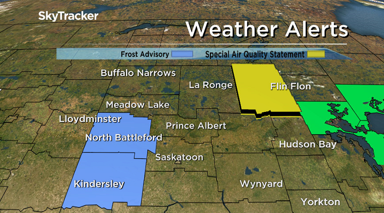
Environment Canada recommends covering up plants and taking preventative measure to protect frost-sensitive plants and trees from potential damage and destruction.
For the latest weather alerts download the Global News Skytracker weather app for iPhone, iPad or Android.
Saskatoon Forecast
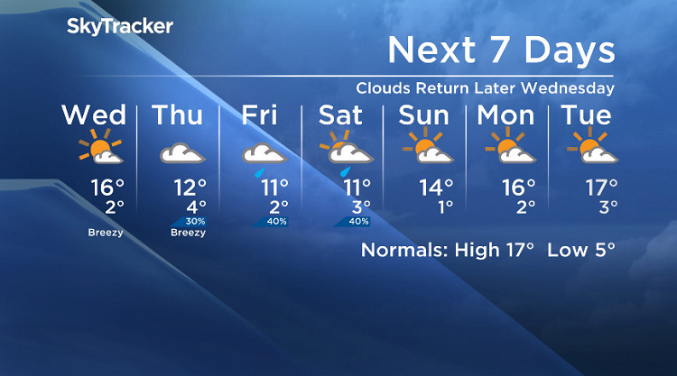
Tuesday
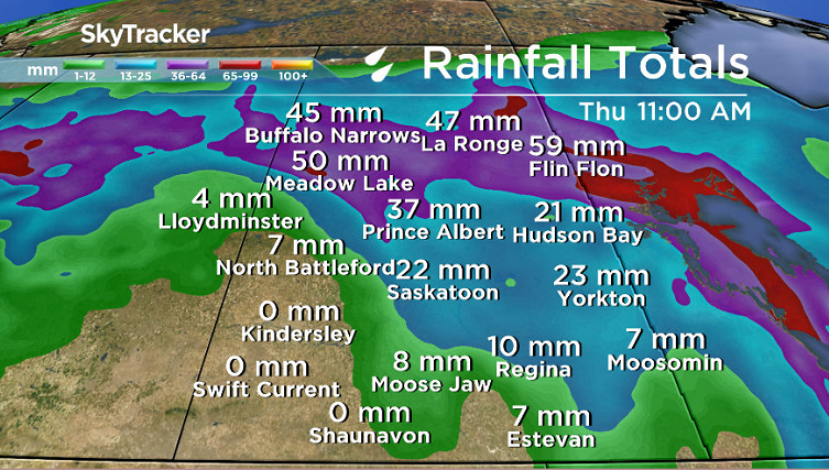
Heavy rain started the day in Saskatoon as a precipitation-packed system and coupled cold front slid through, dumping approximately 15 millimetres of rain on the city by noon, nearly 20 millimetres by mid-afternoon.
Temperatures sat around 12 degrees to start the day with a breezy east-southeasterly wind on top of the rain, which ended up being the most significant rain event the city has had reported at the airport in over a year!
Rain continued into the afternoon before clearing out later on as we struggled up to a daytime high in low double digits.

Get breaking National news
Parts of northern Saskatchewan could see upwards of 50 to 70 millimetres of rain as the system lingers over that area in the coming days.
Tuesday Night
The system responsible for the onslaught of moisture pushed north Tuesday night and along with it went the clouds, which allowed us to cool back toward the freezing mark with a risk of frost.
Wednesday
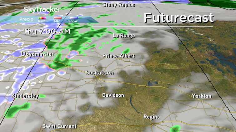
As the system continues to pound the north with rain on Wednesday, the Saskatoon area will see mostly sunny skies for the majority of the day before some clouds move in later on.


A breezy southwesterly wind will kick in during the afternoon and help boost us up to a daytime high in the mid-teens.
Some of the heaviest rain is expected in the Pelican Narrows area, which will help with the firefight in the region.
Wednesday night is when the wrap-around moisture starts to push back into western Saskatchewan and as cooler air injects in with it, precipitation along the border with Alberta is likely to switch over to wet snow.
Thursday-Friday
Wet snow is expected to linger into Thursday morning in parts of western Saskatchewan with cloudy skies and just a chance of showers for Saskatoon.
A better chance of rain moves in on Friday as an upper low pushes in from the south with daytime highs in low double digits both Thursday and Friday.
Weekend Outlook
That upper low will keep us cloudy with a chance of rain and a daytime high in low double digits on Saturday before it moves out on Sunday and allows us back into some sun with a high back in the mid-teens.
Michael Forman took this Your Saskatchewan photo at Pike Lake:

Saskatoon weather outlook is your source for Saskatoon’s most accurate forecast and is your one stop shop for all things weather for central and northern Saskatchewan with comprehensive, in depth analysis that you can only find here.
Comments
Want to discuss? Please read our Commenting Policy first.