Waterton Lakes National Park in southern Alberta issued multiple area closures as of Sunday afternoon due to “extreme fire hazard” near the popular tourist destination.

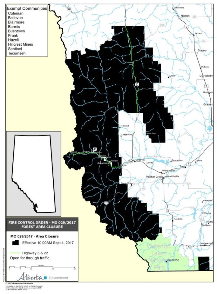
A larger portion of southwest Alberta was also closed Monday (see map below).
Further north, a wildfire is burning near Crescent Falls, closing parks and trails in the area. Fire bans also remained in effect Tuesday west of Red Deer at Jarvis Bay Provincial Park.
For information on the current status of Alberta wildfires, click here
“The Kenow Mountain fire, immediately to the west of Waterton Lakes National Park in southeast British Columbia, is now on the park boundary at Sage Pass and South Kootenay Pass,” Parks Canada said in a Sept. 3 update.
READ MORE: Waterton Lakes National Park and its U.S. sister park get dark-sky designation
- Ontario First Nation declares state of emergency amid skyrocketing benzene levels
- ‘Sciatica was gone’: hospital performs robot-assisted spinal surgery in Canadian first
- Do Canadians have an appetite for electric vehicles? Experts are divided
- TikTok vows to sue over potential U.S. ban. What’s the legal outlook?
The organization said there are three helicopters, resources on the ground and more coming to actively manage the fire. There was no evacuation alert in place as of Monday afternoon.
“Parks Canada first spotted the fire from the air when it was five hectares in size on Aug. 30 in the Kishinena Creek area of British Columbia’s Flathead Valley,” reads the alert. “The fire has since grown to approximately 4,000 hectares.”
The park said public use of national park lands down valley from Sage and South Kootenay Passes was closed earlier Sunday with the closure of the Red Rock Parkway, Crandell Mountain Campground and all trails in that portion of the park.
READ MORE: Controversy over Waterton’s new visitor centre garners attention from Ottawa
The following is a list of areas closed to traffic and travel until further notice:
• All off-trail hiking/scrambling/climbing in Waterton Lakes National Park
• All of Red Rock Parkway
• Crandell campground
• All backcountry campgrounds
• Any visitor use of Cameron Lake (though Akamina Parkway and the Cameron day-use area are open).
All hiking trails in Waterton Lakes National Park are also closed, except the following:
• Townsite and Kootenai Brown Trail
• Linnet Lake Trail
• Bear’s Hump Trail
• Bertha Falls/Bertha Lake Trail
• Lakeshore Trail
• Horseshoe Basin/Oil Basin Loop Trail
• Wishbone Trail
• Vimy Trail
• Crypt Lake/Hell Roaring Falls Trail
For a list of other area closures issued by Alberta Parks, visit the government website here.
At around 8 p.m. on Monday night, the Alberta government announced it was closing “fire protection areas” to the public because of the “dangerous wildfire conditions” in southwestern Alberta.
The closure affects three different “fire control zones” south of Highway 532 to the U.S. border and west to the B.C. border.
Highway 532 is about one kilometre north of Chain Lakes and about 25 kilometres south of Longview on Highway 22. The government said Highway 22 and Highway 3 remain “completely open” for all traffic.
“Alberta Agriculture and Forestry has closed all public lands within Fire Zones 1, 2, and 3 and the public must not enter these areas as they are unsafe,” the government said in a news release. “If anyone is in these areas, they must leave immediately.”
The government said “if anyone from the public believes that they need access to any of the public lands,” limited access may be granted by permit at the following locations:
- Calgary Fire Centre – 8660 Bearspaw Dam Rd. N.W., Calgary
- Chain Lakes Provincial Park Administrative Building – Twp. Rd. 144A, Highway 22, Longview, Alta.
- Blairmore Ranger Station – 11901 19 Ave., Blairmore, Alta.
- Pincher Creek Emergency Services – 655 Charlotte St., Pincher Creek, Alta.
-With files from Phil Heidenreich


Comments