

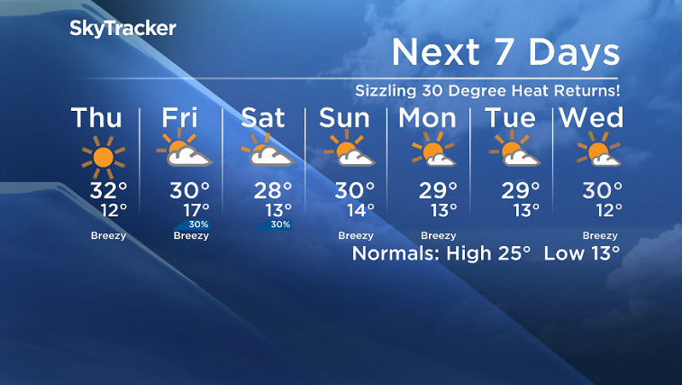
30 degree heat makes its return once again as we ride the ridge into the rest of the week!

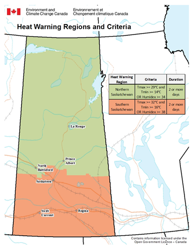
Heat Warning
Environment Canada has issued a heat warning for the Prince Albert, North Battleford, Lloydminster, Meadow Lake, La Ronge, Melfort, Nipawin, Regina, La Loche and Buffalo Narrows areas as well as much of eastern, northern and southern Saskatchewan.
A period with maximum daily temperatures near 29 C or above, and overnight low temperatures near 14 C or above, is expected to begin Wednesday and last through Friday before a weak cold front is forecast to move through.
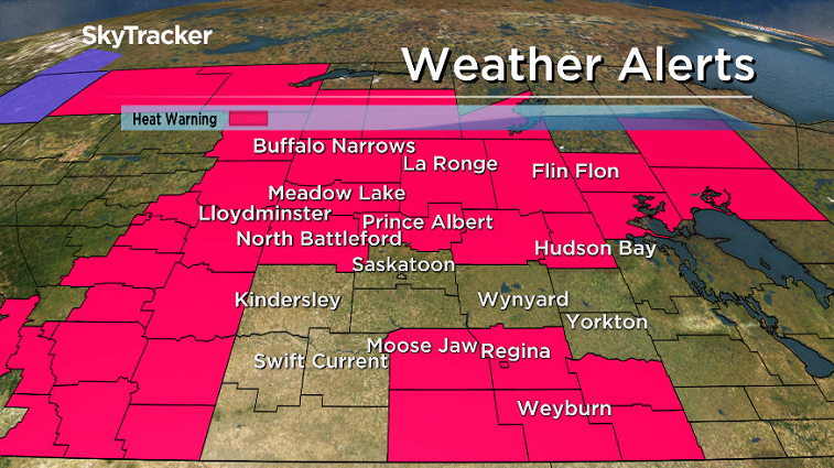
The agency says to watch for the effects of heat illness, including swelling, rash, cramps, fainting, heat exhaustion, heat stroke and the worsening of some health conditions.
For the latest weather alerts download the Global News Skytracker weather app for iPhone, iPad or Android.
Saskatoon Forecast
Wednesday
A few fog patches started the day in Saskatoon with temperatures dipping back just into single digits overnight.
Sunny skies were in full swing to start the day, helping temperatures rise up into the mid 20s by noon.
Blue skies and sunshine dominated the rest of the day with a surface high passing by as we warmed up to an afternoon high in the upper 20s.
Thursday
Saskatoon gets into the heart of the heat on Thursday with an upper ridge boosting the mercury into the low 30s by afternoon.

Once again nothing but sunshine will be the name of the game throughout the day with a high UV index, meaning exposed skin can burn in minutes, so be sure to slap on some sunscreen!


Friday
30 degree heat should linger on Friday, but we’ll get into a brief blip in the ridge, which will allow a low pressure system and trough to slide through.
The result will be a chance of showers, particularly early in the day, with some more clouds across the region as well before we should get into some sunshine again later on.

Weekend Outlook
A few models are bringing in a brief disturbance through on Saturday that may bring in mostly cloudy skies with a slight chance of showers as we warm up to an afternoon high in the mid-to-upper 20s.
Sunday is likely to start off with some sunshine with rebounding temperatures back into the 30s, but late in the day will likely see more clouds bubble up with a very slight chance of late day showers as a system moves in.
Jeff Wizniak took this Your Saskatchewan photo in Saskatoon:

Saskatoon weather outlook is your source for Saskatoon’s most accurate forecast and is your one stop shop for all things weather for central and northern Saskatchewan with comprehensive, in depth analysis that you can only find here.
Comments