
After the second warmest November ever recorded in Saskatoon, we plunge into the deep freeze into December!

November Numbers
Saskatoon just saw the second hottest November ever recorded in the city!
Temperatures averaged out just shy of two degrees above freezing throughout the month (technically 1.9 degrees) – a whopping eight degrees warmer than normal!
This is incredibly impressive, especially when averaging out 30 days of data.

READ MORE: October 2016 is way wetter and colder than normal in Saskatoon
There was only one other year where the city saw a warmer average temperature, which was 99 years ago in 1917, when we averaged out at 2.7 degrees.
It was the warmest November in recorded history in Regina, Estevan, Key Lake and Yorkton, and was the second hottest ever in Prince Albert.


Precipitation-wise we saw 9.2 millimetres of rain and melted snow and other forms of precipitation throughout the period, slightly below our normal amount in November of 13 millimetres.
Saskatoon Forecast
Today
The first day of December and meteorological winter kicked off on a mild note with temperatures only dipping back to -4 overnight, warming up to -2 by noon!
This is quite impressive, especially given that our normal daytime high for this time of the year is -6 and an average overnight low is -14.
Cloudy skies started the day and will continue right through the afternoon with the mercury sitting around -2 for the remainder of the day.
Tonight
Clouds stay around tonight with temperatures dipping back to around -5.
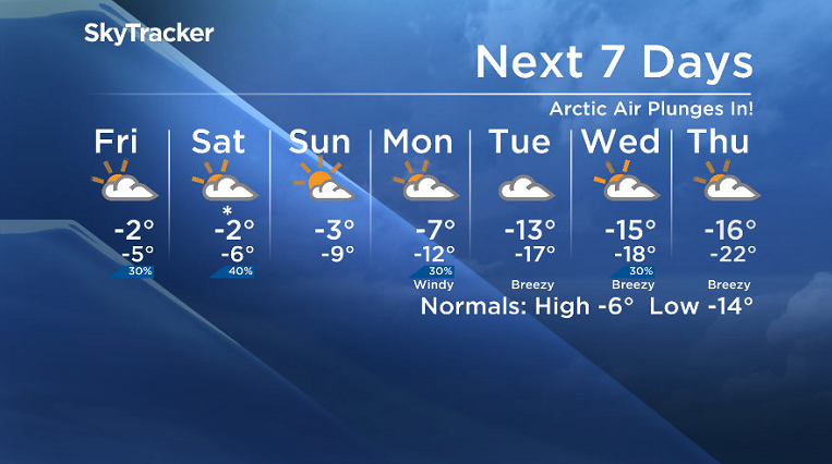
Friday
-10 is around what it’ll feel like with wind chill when you wake up tomorrow morning before temperatures push up to around -2 for an afternoon high, which has become a trend for daytime highs this week.
It will once again be a mostly cloudy day with a bit of clearing possible into the evening.


Weekend
A developing low pressure system will quickly swing through on Saturday bringing with it the clouds and a decent chance of snow.
Behind that system we should see some clearing on Sunday as we start to dive back into the deep freeze.

Temperatures should hold up around -2 or possibly even pushing up to -1 on Saturday before falling back a few more degrees for a high on Sunday and then dropping toward minus double digits late in the day.
Work Week Outlook
The real deep freeze settles in early next week as arctic air plunges in under mostly cloudy skies with a chance of flurries, dropping temperatures back into double digits on Monday before falling even further into minus teens for Tuesday.
Wind chill values could push toward the -30s mid-week with morning temperatures possibly even dipping into the -20s by later on in the week.
Jodine Siebert took this Your Saskatchewan photo near Borden:

Saskatoon weather outlook is your one stop shop for all things weather for Saskatoon, central and northern Saskatchewan with a comprehensive look at your local forecast that you can only find here.
- Canadian man dies during Texas Ironman event. His widow wants answers as to why
- ‘Sciatica was gone’: hospital performs robot-assisted spinal surgery in Canadian first
- Honda’s $15B Ontario EV plant marks ‘historic day,’ Trudeau says
- Several baby products have been recalled by Health Canada. Here’s the list
Comments