
WINNIPEG — September is just around the corner but summer is still hanging on in southern Manitoba.

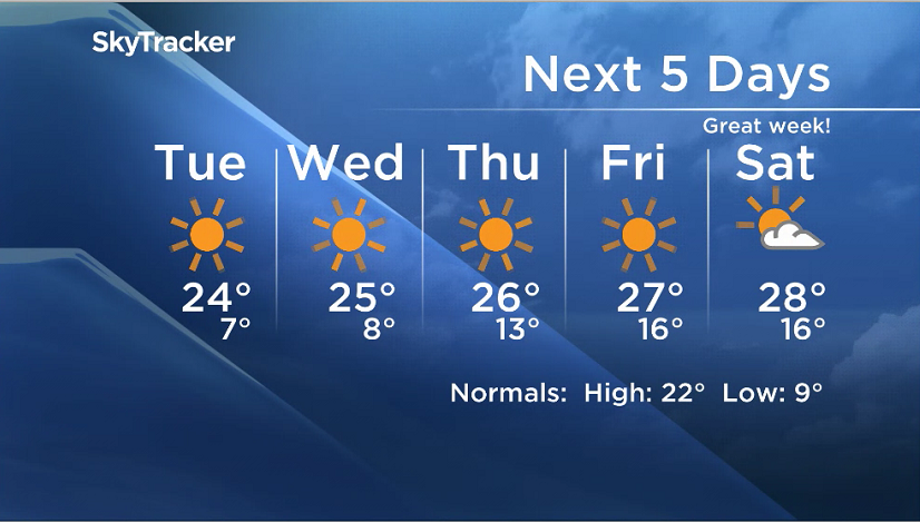
After a brief cold front moved through Sunday night bringing rain to some parts of the province we are looking ahead to lots of sunshine and dry conditions.
A ridge of high pressure will move into the Red River Valley and those blustery winds we experienced over the weekend will disappear.
Evenings will be cooler, but daytime highs are expected to be seasonal (22 Celsius is the normal) and then gradually get warmer as we get into the second half of the week.
While storms rolled through parts of the province Sunday night, Winnipeg received very little in the way of precipitation.


Other areas were hit by severe thunderstorms and brought hail and large amounts of rain.

Get daily National news
Here’s a breakdown of the storm details Sunday night from Environment Canada.
Rainfall amounts:
- Taylor’s Point 46 mm
- Killarney 40 mm
- Narcisse 47 mm
- Pinawa 31 mm (CoCoRAHS)
- Teulon 23.9 mm (CoCoRAHS)
- Arborg 19.6 mm (CoCoRAHS)
- Morden 18.3 mm (CoCoRAHS)
Hail reports:
- Loonie sized near Pipestone at 4:00 p.m.
- Golfball sized near Lauder at 4:30 p.m.
- Nickel size hail near Glenella at 5:10 p.m.
- Toonie to hen egg sized hail in Deloraine at 6:50 p.m.
- Quarter sized hail near Boissevain at 7:25 p.m.
- Nickel sized hail in Alonsa at 7:30 p.m.
Comments
Want to discuss? Please read our Commenting Policy first.