


For many, Irene was the hurricane that wasn’t.

Days before the once Category 3 storm made landfall, evacuations were ordered and windows were boarded shut.
In New York City, Mayor Michael Bloomberg made the unprecedented move to shutdown the city’s entire transit system for most of Saturday and all of Sunday, under the auspices that Irene would batter Manhattan.
But once Irene passed, New Yorkers seemed almost disappointed the city didn’t get the damage and destruction that might have been.
Irene struck North Carolina as a Category 2 storm, with winds of 177 km/h, before whipping up the entire U.S. coast causing billions of dollars in damages and at least 40 deaths as it churned inland toward Quebec and northwestern New Brunswick.
Areas that didn’t get hurricane forced winds, certainly did get the rain.
New Jersey Governor Chris Christie said Sunday he had no tolerance for the second guessing of decisions made in the lead up to the storm.
The death and destruction may not have been as drastic as when Hurricane Katrina hit the Gulf Coast six years ago, but it could have been much worse if precautions had not been taken, officials such as Christie and U.S. President Barack Obama insisted.

Get breaking National news
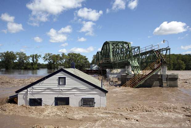
Areas in New Jersey, Pennsylvania, and in particular, Vermont were inundated by flash floods brought on by the downgraded tropical storm’s heavy rains.
The flooding brought on by Irene is the worst Vermont has seen since 1927.
In Canada, coastal areas of the Maritimes were also spared from the brunt of Irene, but Montreal and eastern townships of Quebec fared worse, with about 200,000 people losing power and at least one person feared dead following a landslide near the town of Yamaska.
The storm did what was expected, says Global meteorologist Trevor Adams.
“Once the eye of the storm is over land, then a big portion of the storm is getting cut off from access to the moisture that it needs,” Adams said. “It begins to weaken immediately.”
And while the storm quickly broke up over land, becoming a tropical storm early Sunday and post-tropical by Monday morning, its moisture didn’t dissipate and that’s when flooding occurs and you still have fairly strong sustained winds that can continue to cause damage.
But Irene did have potential to be one for the record books, like many people up the eastern seaboard believed.
It was a massive storm, Adams says, and it had a very low pressure at its centre which, in the right conditions, increases wind speeds dramatically.


“Had this storm been in the Gulf of Mexico or taken a westward path in the Caribbean, it would have grown into a monster, probably a Category 4 or 5 storm.”
American forecasters appeared to atone for their predictions in the media Monday.
James Franklin, chief of the hurricane specialist unit at the U.S. National Hurricane Center told the New York Times he had expected the storm to grow after passing over the Bahamas earlier in the week.
“We were expecting a stronger storm to come into North Carolina,” Franklin said. “What we got wrong was the structure of the storm.”
He added that while NHC accurately predicted the storms track, it had missed the mark on its strength.
Adams says you have to wait until the storm has passed to truly assess its impact, not what didn’t happen or if it lived up to the hype.
“Forecasters just give you the facts of the storm,” Adams says “… you’re getting this much rain, this much wind.”
How politicians and emergency organizations act on that information is a “critical factor” he says.
“You can present the information, but it’s what people do with it or what they don’t do with it that at the end of the day is a bigger issue.”
Hurricane season reaches its peak during the month of September. There have been 10 named storms so far this year, but Irene was the first to reach hurricane status. A tropical disturbance of the west coast of Africa Monday became the eleventh named storm, Katia.


Comments
Want to discuss? Please read our Commenting Policy first.