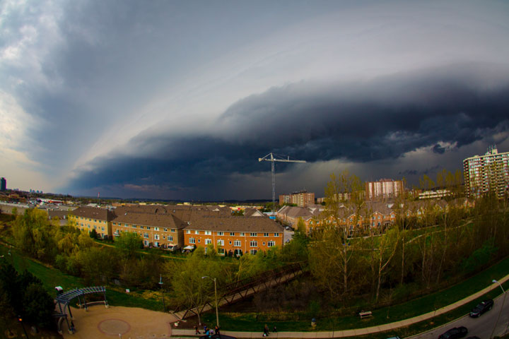
TORONTO – Storm season has arrived.

The storm system that blew across southern Ontario Tuesday evening — which triggered severe thunderstorm watches and warnings in southwestern Ontario — was fed by very warm, moist and very humid air.
Though the GTA was definitely warm and humid, it wasn’t quite as sultry as other parts of the region: the hottest place in Canada Tuesday was Collingwood with a high of 29.4 C.
READ MORE: Summer weather safety
That kind of day, referred to by Environment Canada as a 3H day — hot, humid, and hazy — is ideal for severe storms in Ontario. Those days can also make any tornadoes more difficult to see, which can be especially dangerous.
Damage was reported in Mildmay on Tuesday and Environment Canada investigators are visiting the town near Wingham in order to determine whether or not there was a tornado. Investigators may also head to Listowel where there were other reports.
The video above is of a possible landspout tornado from Tuesday’s storm. These types of tornadoes differ from a more common tornado as they are not associated with mesocyclones, or storm systems. They occur when circulation forms at the ground (rather than from the cloud, as in tornadoes) and updrafts and heating create circulation. Though weaker than tornadoes, they are still dangerous.
The system looked rather ominous as it approached the GTA, but for the most part it didn’t deliver particularly heavy rains and thunderstorms. What it did create, however, was what causes the most damage in Ontario during the summer months: high winds.
READ MORE: Thunderstorms 101–Derechoes, supercells, multi-cells…what it all means
“There seems to be this fixation, generally, on tornadoes, but in Ontario, these downburst events are happening more frequently and they’re equally as dangerous to the vast majority of tornadoes that we get,” Geoff Coulson, warning preparedness meteorologist with Environment Canada, told Global News. “Some of these gust fronts can be moving at 80, 90, 100 kilometres an hour.
“They can go from the western horizon to your position in a matter of minutes. And if you haven’t thought about where you’re going to take shelter, you can be caught in a very vulnerable or dangerous situation.”
The dark clouds that swept across the region were part of a gust front associated with a system called a squall line. Gust fronts occur on the edge of cooler air associated with a storm system which in turn produces a shelf cloud. That’s what people across southern Ontario witnessed on Tuesday.
After the storm passed, you may have noticed clouds that seemed ragged, almost bubbling. That is referred to as the “whale’s mouth” and is created by warmer air being lifted above the colder air of the gust front.
Coulson said that the severe weather season has gotten off to a slow start due to the colder temperatures. The moisture from the Gulf of Mexico, which tends to feed our storm systems, has kept away from our region. But the storm season is starting.
“For sure that warm weather will come back by late in the month, and with it will come the possibility of damaging thunderstorms,” Coulson said.
Looking ahead, there will be a lot of rain in the forecast for Wednesday to Thursday, with the possibility of thunderstorms, which could once again be severe in southwestern Ontario.
As a reminder, a thunderstorm or tornado watch is issued when conditions are favourable for severe weather. A warning is when hazardous weather is imminent or occurring.
Remember to keep an eye on the sky and to always be aware of the weather in your area.
To get real-time weather for your area, download the Global News Skytracker weather app.


Comments