
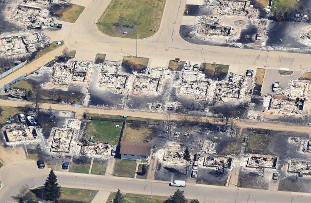
This map shows the extent of damage from wildfires in Slave Lake, Alberta.

The map combines a satellite photo of Slave Lake, taken on May 18, 2011, with a map released by the Alberta government, showing the damaged areas of the town.
Approximately one third of Slave Lake was damaged by wildfires. The damage is clearly visible in the satellite photo and is mostly concentrated in the southeast corner and centre of the town. Zooming in on the map clearly shows some houses that are severely burned and many that have remained safe from the fire.

Get daily National news
Red areas were destroyed, Pink sustained some damage and green areas were unaffected.
Use your mouse to navigate the map. Click and drag to move around the area. Zoom in and out using your mouse’s scroll wheel or by clicking on the zoom tool in the corner of the map.
To use the map, you need to download the Google Earth plugin.
All images courtesy: Google Maps & Satellite images courtesy of GeoEye
Fire Damage Map supplied by Town of Slave Lake
Comments
Want to discuss? Please read our Commenting Policy first.