


A significant change is coming to Toronto’s weather pattern as the official start to summer nears.

Global News meteorologist Anthony Farnell said the hottest weather of the season so far is set to move in early next week.
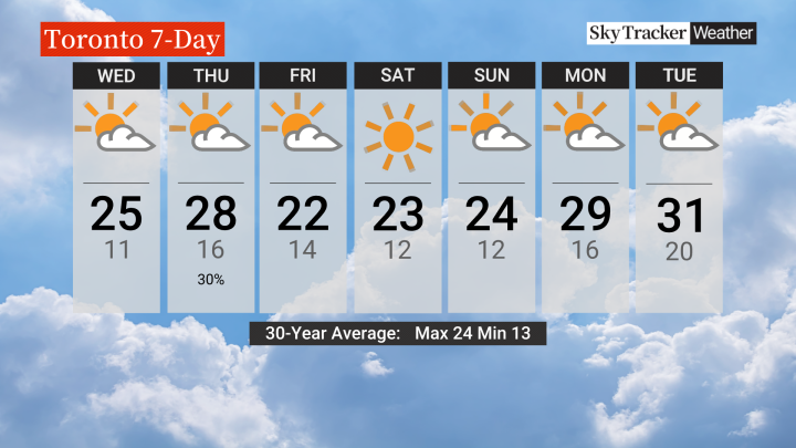
Toronto has yet to see its first 30-degree day of the year, but that will likely happen early next week, Farnell said.
He said “a large ridge of high pressure” will build along the east coast of the United States.
“This will bring several days of hot temperatures and higher humidity levels,” he said.

“It will likely feel like the upper 30s to almost 40 for several days leading up to the official start to summer on Thursday, June 20.”
Farnell said June so far has been off to a cool start across most of Canada, “but the turnaround will be most significant around the Great Lakes.”

Get daily National news
So far this year at Toronto Pearson Airport, the warmest temperature has been 29.7 C on both May 21 and 22. In June, the warmest it has been was 26.8C.
On Monday, the temperature reached a high of just 16.3 C at Pearson.
- Large swath of southern Ontario set for heavy rain to start Easter weekend
- Another spring snowstorm snarls Calgary roads, causes dozens of crashes
- Snow in the forecast for Calgary, Edmonton areas ahead of the long weekend
- ‘Stay connected’: Atlantic Canada’s messy winter has been hard on students, seniors


“It is still too early to say how long the hot spell will last but current indications are that it will peak sometime late next week,” Farnell said.
“With the higher temperatures and humidity, afternoon thunderstorms are also possible.”
And as we officially move into summer, Farnell said there will be more hot and humid days to come.
“I am forecasting prolonged hot spells and a hotter than normal summer, but also with a continuation of above normal rainfall in the months ahead,” he said.

Comments
Want to discuss? Please read our Commenting Policy first.