

There really won’t be that much accumulation, but the Toronto area could see its “most significant snowfall of the season so far” on Thursday as a clipper system moves in.

“Normally, a quick-moving clipper system like this would not be considered significant in mid-February. However, it speaks to just how little snowfall the GTA and southern Ontario have received so far this winter,” Global News meteorologist Ross Hull said.
Hull noted that so far this month, only 0.2 cm of snow has been recorded at Toronto Pearson International Airport and we’ve only seen 31 per cent of the normal amount of snowfall this winter.
The largest daily snowfall so far this season at Pearson was on Jan. 9, when 5.6 cm was recorded.
“That will all change come Thursday as a system moves in by early afternoon and sticks around into the early evening,” Hull said.
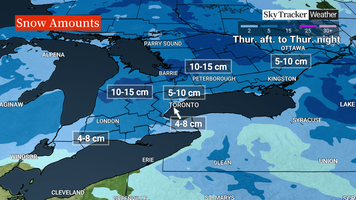
“This looks to be a 5-10 cm event for much of the GTHA — although that total will likely be closer to 4-8 cm closer to Lake Ontario and downtown Toronto where there could be some melting initially as the snow moves in.”

Get breaking National news
Some places north of the GTA, into cottage country towards Haliburton and Kawartha Lakes, could see 10 to 15 cm, Hull said.
“This is good news for ski resorts,” he said.


Hull said drivers should be prepared for an impact on the afternoon and evening commutes.
The system will also bring breezy southeast winds which could reduce visibility.
After the clipper moves through, northwest winds will develop as temperatures drop and lake-effect snow squalls could impact parts of southern Ontario and possibly the GTA Friday morning.
“Looking ahead to the Family Day long weekend, there will be the potential for more flurries and light snow at times on Saturday and Sunday with some periods of sunshine, too,” Hull said.
“Temperatures will be low enough to keep all the snow from melting, so it should stick around through the holiday weekend.”

Comments
Want to discuss? Please read our Commenting Policy first.