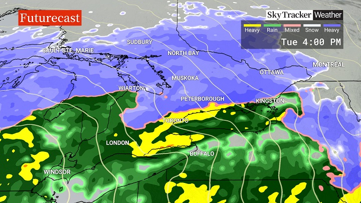
A major storm is headed to southern Ontario and will begin impacting the region Tuesday morning.

Meteorologists are continuing to track the system and where you are will determine how much snow or rain you see.
Global News meteorologist Ross Hull said snow is expected to begin Tuesday morning for much of southern Ontario, likely at the end of the morning commute for the Greater Toronto-Hamilton Area.
“It will begin as wet snow then transition to rain by the afternoon for areas closer to Lake Ontario where 2 to 5 cm of wet snow is likely,” Hull said.
North of Highway 407, precipitation will likely stay as wet snow for longer, bringing the possibility of 10 to 15 cm, before transitioning over to rain, he said.
During the transition, there may also be some freezing rain and ice pellets.
Heaviest snow totals are expected for eastern Ontario where 15 to 25 cm is possible, Hull said.
Late Tuesday, all of southern Ontario was under some form of weather advisory, with a winter storm warning in effect for the Ottawa area, a snowfall warning stretching from Orillia to just west of Perth, and areas south under a special weather statement and / or a winter weather travel advisory.
A winter weather travel advisory was in effect for the Greater Toronto Area, warning of difficult driving conditions once the snow starts.
“At this point, it appears that the heaviest snow will arrive after the morning commute, but that the afternoon commute could be significantly impacted,” the advisory for Toronto and areas north and west of Lake Ontario said.
“Motorists should expect hazardous winter driving conditions and adjust travel plans accordingly. Surfaces such as highways, roads, walkways and parking lots may become difficult to navigate due to accumulating snow.”
Hull said even though Toronto won’t see significant snow, “the roads will be quite messy considering the snow to start then the transition to rain (15-25 mm possible).”

Get daily National news
He said he’s not expecting significant flooding, but there will be pooling on roadways and some flooding possibly in poorly drained areas.
Gusty winds out of the east are also forecasted with the system, with the strongest winds near 100 km/h expected in the Niagara Region, Hull said.
Toronto Pearson International Airport said in a post on X that they are monitoring the storm, but no “major disruptions” are expected for air travel.
“But if you are travelling tomorrow, consider leaving extra travel time,” the post said, adding that travellers can check the status of their flight online.
Ontario Provincial Police Sgt. Kerry Schmidt told drivers in the GTA to give themselves extra time due to the storm, and said to slow down and drive according to the conditions.
Meanwhile, another major system is expected to hit southern Ontario Friday night into Saturday.


Comments