

After three consecutive La Niña winters, a moderate El Niño is now well established in the central Pacific Ocean.

This warmer-than-normal water affects the jet stream and weather patterns around the planet and often leads to milder and less snowy winters in Canada. The weather pattern also becomes more variable, with wild swings in temperature and an increased potential for ice storms in parts of central Canada and bigger snowstorms in the Maritimes.
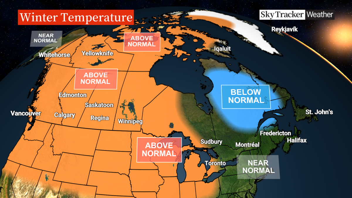
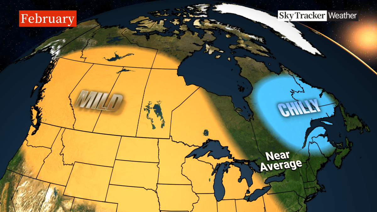
Confidence is also high for a mild Western Canada winter with less snow.
It is important to note that no two El Niños are alike and there are so many other factors that affect our weather pattern on a global and local scale.
Let me break down what to expect this winter across Canada.
Winter in British Columbia
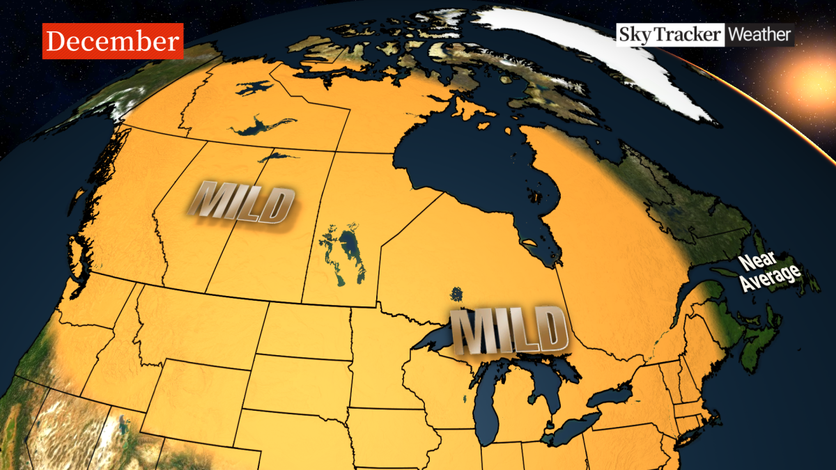
Unfortunately, the mild and sunny November has come to an end but that calm weather will return on several occasions through the upcoming season.
It will likely be quieter than the past three La Niña winters. The strongest storms will follow the sub-tropical jet and slam into California rather than the Pacific Northwest.
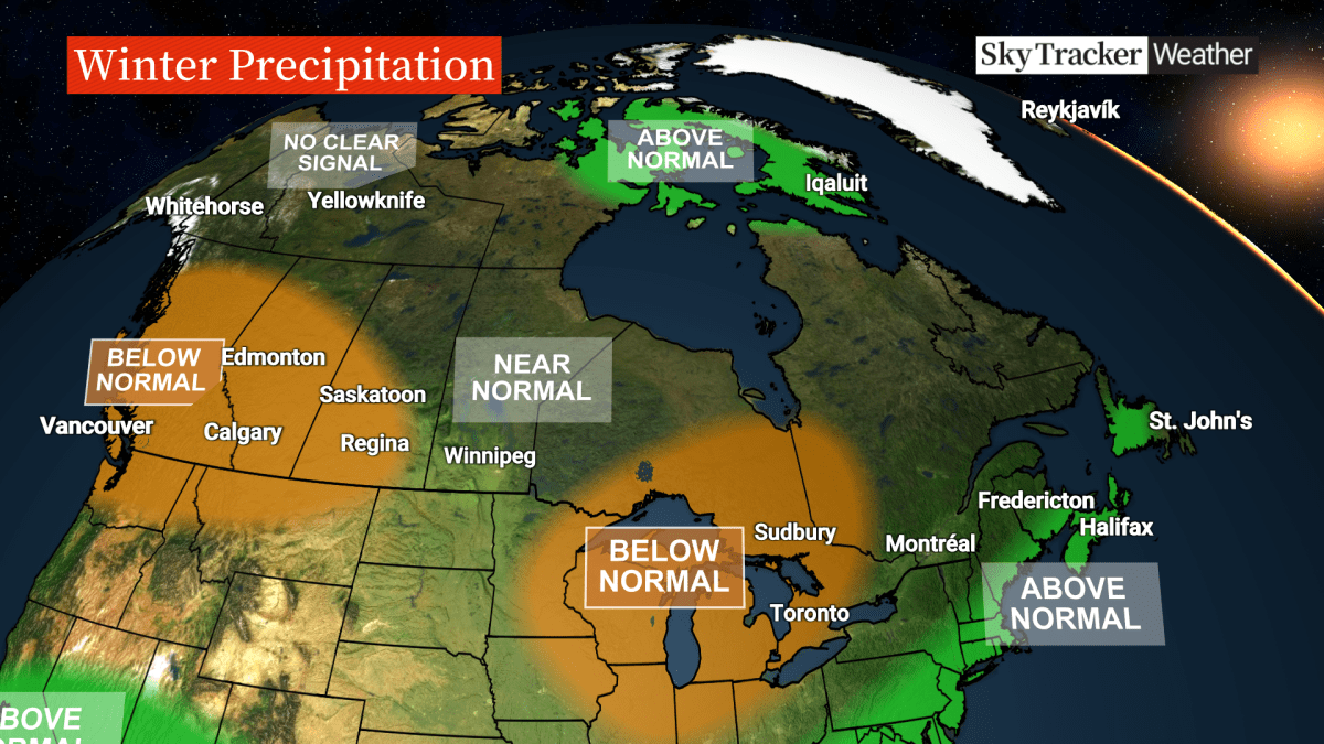
This leads to milder temperatures with less coastal rain and less mountain snow across the province.
A few Arctic intrusions are still likely for the Lower Mainland and Vancouver Island, but overall, milder Pacific air will dominate the weather pattern this season.
There is some good news for winter sport enthusiasts because December is looking quite snowy before the storm track shifts south. Time to hit the slopes over the holidays.
Winter in the Prairies
El Niño is synonymous with milder winters in the Prairies.
A weaker polar jet stream means less of that brutally cold Arctic and Siberian air. Keep in mind that even a milder winter in Saskatchewan and Manitoba is still brutally cold most of the time.

Get breaking National news
I’m still willing to bet that there will be golfing around Calgary at some point this winter with those Chinook winds.
The weather will be more variable than normal with plenty of wild swings in temperature as Pacific air occasionally makes its way over the continental divide into the Prairies. Snowfall will likely be below seasonal in Alberta and Saskatchewan and closer to average in Manitoba.
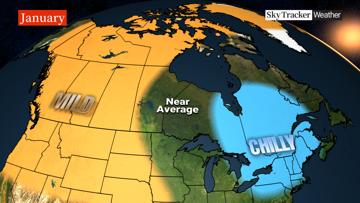
Special note: Watch out for a period of extremely cold weather arriving around the holidays and lasting through the first part of January.
Winter in Ontario and Quebec
A mild December is nothing new for Ontario and Quebec.
The recent trend over the past two decades has been for a later start to winter. The tradeoff is often a delayed start to spring with lingering snow and chill into April.
This could partially be due to the warm multidecadal phase of the Atlantic Ocean, along with the impact of climate change. El Niño winters in central Canada are variable, with weeks of above-seasonal temperatures followed by shorter-duration cold spells.
- Wildfire smoke blankets Kelowna, prompting health warnings and disrupting summer plans
- NDP calls for public inquiry into Ford government’s wildfire preparedness, response
- Thorhild, Westlock counties declare state of agricultural disasters due to rain
- Montreal jazz legend Oliver Jones remembered as a virtuoso, mentor and humble man


Here’s hoping there are enough consecutive chilly nights to open the Rideau Canal, which remained shut all last winter for the first time on record. Areas farther east through central and northern Quebec will likely tap into much colder air and below-seasonal temperatures are more likely.
In moderate El Niño winters, the storm track often passes south of the Great Lakes, bringing less snow to southern Ontario and Quebec. The icing hazard is something to watch this winter with an increased risk of freezing rain events, especially for the Ottawa and St. Lawrence Valley.
Remember the ice storm of 1998? That was also an El Niño winter.
Special note: The weather pattern could turn very cold and snowy for a couple of weeks around Christmas and New Year’s before backing off again in the second half of winter.

Winter in Atlantic Canada
The eastern third of Canada is the only place where temperatures will likely remain seasonal to even well below seasonal this winter.
There’s also a higher likelihood of blocking high pressure developing over Greenland and Nunavut as the winter progresses, which would help push that frigid Arctic air farther south into the Maritimes, Newfoundland and Labrador.
In El Niño winters, the subtropical jet is stronger, which generally keeps the big storms farther south across the southern United States.
However, with warmer water lurking off the East Coast, those systems will likely turn up the Eastern Seaboard, impacting Atlantic Canada with above-normal snowfall but also quite a bit of rain and icing.
Winter in Yukon, N.W.T., Nunavut
Climate change impacts Canada’s North more than anywhere else in the country.
Milder-than-normal winters have become more and more common and I think this winter will be no different. The centre of the above-seasonal temperatures will be found across the Northwest Territories but will extend into Yukon and Nunavut as well.
Blocking over Greenland later in the winter will likely bring higher-than-normal snowfall to the eastern Arctic.
Comments
Want to discuss? Please read our Commenting Policy first.