
TORONTO – It was a storm that caught everyone off guard.

Though Environment Canada had issued a Special Weather Statement early in the afternoon, the severe thunderstorm warning for Toronto, Vaughan, Richmond Hill, Markham, Brampton and Mississauga wasn’t issued until 5:55 p.m., long after the hardest part of the storm had passed through the area.
Read By the Numbers: 2013 Toronto flood
Mark Seifert, a meteorologist with Environment Canada said that thunderstorms are “notoriously difficult” to predict. “Until they develop.”


“We have been in a very hot and humid air mass for the past couple days and this morning’s sunshine helped destabilize the atmosphere,” said Global Toronto Meteorologist Anthony Farnell.
Read: 42 areas in GTA at risk from serious flood, experts warn
“Thunderstorms formed around 3 p.m. this afternoon to the west and north of Toronto and converged on the city around 5 p.m. The combination of tropical air, weak steering winds causing very slow moving storms, and thunderstorms redeveloping over the same area created the perfect ingredients for flooding.”
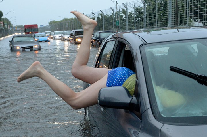
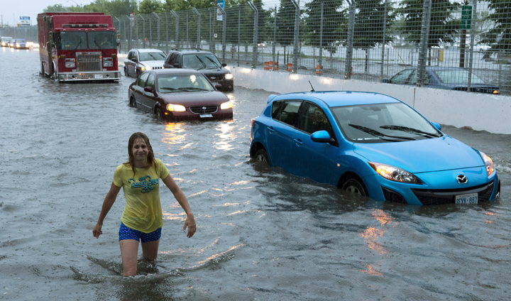
Once it was apparent that the slow-moving system had dumped more than 40mm of rain in areas, Environment Canada issued a severe thunderstorm warning.
“It was basically, a couple of thunderstorms that passed over an area. What resulted was a high rain,” said Seifert. “And we had two things contribute to it: first, were storms that produced heavy rain; the second that it was a slow-moving system.”
Watch: Meteorologist Anthony Farnell talks about Monday’s record storm.
Seifert said that the problem for Toronto is that the rain has nowhere to go. In a concrete city, the sewers can’t handle the intense rain.
Siefert added that the storms resulted in heavily localized flooding: whereas Toronto has seen 90 mm and Pearson has seen 106 mm, Buttonville Airport in Markham received only 17. Hamilton has received negligible rain.
The average rainfall for July is 74 mm. The single day record for rainfall is 121.4 mm set during Hurricane Hazel on October 15, 1954.
Though the rain is continuing, it looks as if most of it will pass west of the city, affecting Brampton and Mississauga.
Seifert added that the forecast is much of the same over the next two days: hot, humid with a chance of thunderstorms.
Comments