

Drought conditions come to an end in Saskatoon as rain moves in.

Saskatoon Forecast
Today
15 degrees was where Saskatoon started the morning under partly to mostly sunny skies before clouds associated with a system pushing into the southeast moved in.
A southeasterly wind around 20 to 30 km/h with gusts upwards of 35 km/h kicked in today as we warmed up into the 20s before noon.
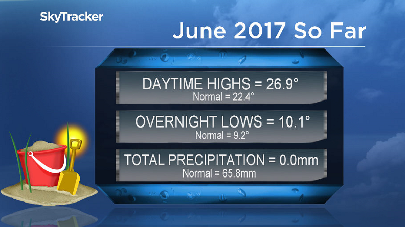
Saskatoon has been seeing drought-like conditions so far this June with no precipitation reported at the airport in what is normally the wettest month of the year!
Winds will continue to strengthen with gusts up to 50 km/h possible this afternoon as we warm a few degrees into the 20s before some showers may sprinkle the area into the evening.
Tonight
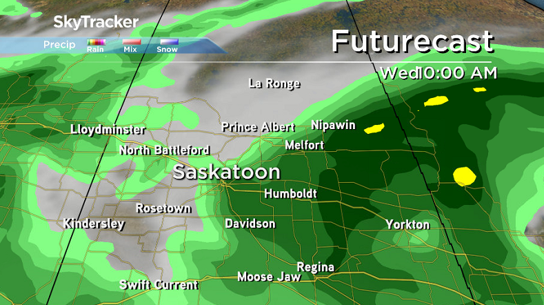
The chance of showers continues tonight before a break overnight and then some more organized rain is likely to move in before morning as we cool down to a low in low double digits.
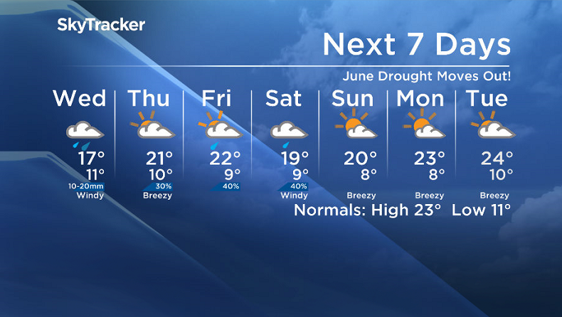
Wednesday
This vertically stacked, precipitation packed system will push into eastern Saskatchewan on Wednesday, with some wrap around rain expected to hit the city with 10 to 20 millimetres during the day.
Temperatures will remain cooler, in the mid-teens, with a northerly wind in the 20 to 30 km/h range with gusts upwards of 40 to 50 km/h as we sit on the chilly side of the low.
Thursday-Friday
Mostly cloudy skies with a slight chance of showers will linger on Thursday as the system pulls off further to the east, before another disturbance ripples through Friday, bringing a risk of thunderstorms later in the day.
Daytime highs are expected to rebound, back into the low 20s for the rest of the week with morning low possibly slipping back into single digits.


Weekend Outlook
The weekend is still looking like it’ll start off unsettled and mostly cloudy with a chance of showers on Saturday before we may get into some sun under partly cloudy skies on Sunday.
Daytime highs will struggle into the high teens on Saturday, but are likely to jump up into the low 20s by Sunday before pushing up even further into next week.
This Your Saskatchewan photo was taken at Grand Coulee by Mitchell Langlois:

Saskatoon weather outlook is your source for Saskatoon’s most accurate forecast and is your one stop shop for all things weather for central and northern Saskatchewan with comprehensive, in depth analysis that you can only find here.
- Message found in bottle in New Brunswick begs finder to ‘let me out’
- Canadians should listen to CSIS head on TikTok warning, Trudeau says
- Heading out for the May long weekend? Here’s what to expect for gas prices
- Fort McMurray wildfire behaviour expected to be ‘subdued’ with cooler temperatures, rain
Comments