

Heavy snow and freezing rain contribute to widespread power outages across northern Saskatchewan. Find out when we’ll dry out and warm up!

Power Outages
https://twitter.com/Froanna/status/788016252002312192
Multiple hours of freezing rain and heavy snow were reported across the north over the weekend.
As a result, trees and power lines are falling under the weight.
Power outages have been reported in La Ronge, Waskesiu, Meadow Lake, Shellbrook, Weyakwin, Stanley Mission, Missinipe, Grandmother’s Bay, Southend, Île-à-la-Crosse, Canwood, Sturgeon Lake First Nation, Pinehouse Lake, Green Lake, Goodsoil, Pierceland, Montreal Lake, McPhee, Ministikwan, Makwa Lake, Dorintosh and Waterhen, Jeannette Lake.
Snowfall Warning
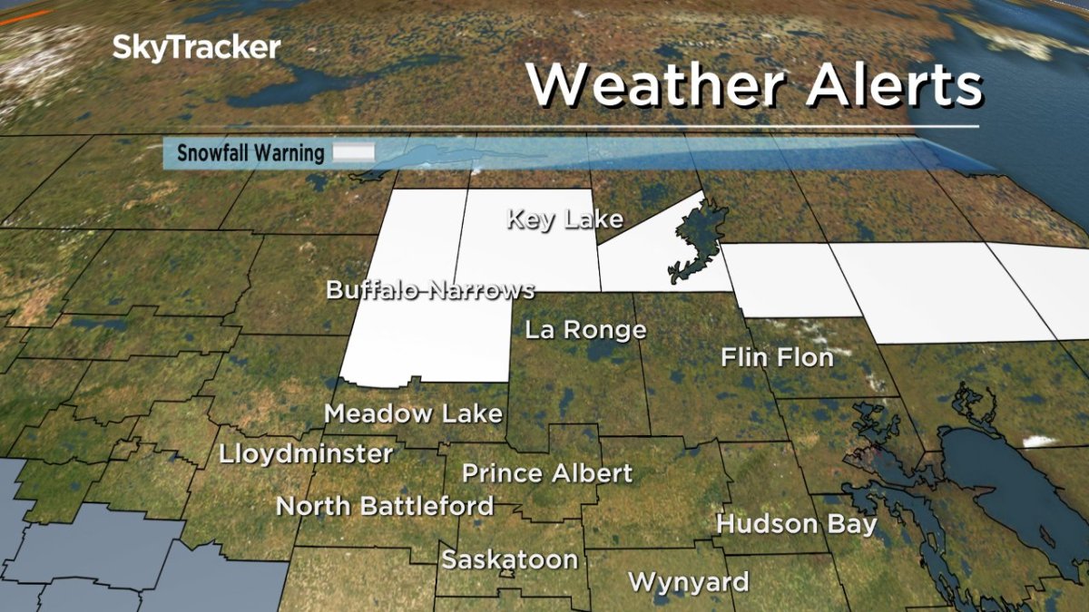
A snowfall warning remains in place for the Buffalo Narrows, La Loche, Key Lake and Southend areas for 10 to 15 centimetres of snow expected.
A low pressure system tracking into central Manitoba is producing heavy snowfall over parts of northern Saskatchewan.
Buffalo Narrows has already received snowfall amounts exceeding 15 cm.
A further five to 10 cm of snow is expected to fall Monday before tapering off overnight.
Visibility may be suddenly reduced at times in heavy snow. Prepare for quickly changing and deteriorating travel conditions.
For the latest weather alerts download the Global News Skytracker weather app for iPhone, iPad or Android.
Motorists planning to head out on roads are advised to use caution and check in with Saskatchewan Highway Hotline before heading out.
Saskatoon Forecast
Today
After a wet end to the weekend, mostly cloudy skies have dominated our Monday after starting out just above the freezing mark.
By noon, we were sitting around 3 degrees above a moderate west-northwesterly wind around 30 km/h, gusting to 41 km/h helping to mix down some milder air.
The mostly cloudy trend will continue through the afternoon with the mercury rising up potentially to one more degree and breezy conditions sticking around.
Tonight
Mostly cloudy skies will stick around tonight as temperatures dip back a degree or two below freezing.


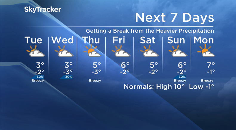
Tuesday
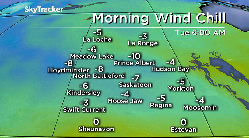
Wind chill values will make it feel around -7 tomorrow morning when you head out the door before we warm up through the day back up to an expected high around 3 degrees.
We’re looking at another mostly cloudy to completely cloudy day with a slight chance of flurries in the afternoon in an unsettled northwesterly flow aloft behind the low pressure system that brought the snowfall warning to the north as it pulls off to the east.
Wednesday-Friday
Behind that system we get into a weak high pressure ridge that’ll try to build in, however mid-level moisture and a few upper disturbances will likely keep us mostly cloudy Wednesday with a daytime high around three degrees.
We should manage to see some sunshine on Thursday though before some more clouds move back in on Friday as the mercury pushes up into mid-single digits for afternoon highs.
Weekend Outlook
There is still quite a bit of model discrepancy with the weekend forecast, however at this point it looks like we’ll see partly to mostly cloudy skies with daytime highs in mid-single digits.
We’ll keep an eye on it though and bring you the latest information through the week.

Saskatoon weather outlook is your one stop shop for all things weather for Saskatoon, central and northern Saskatchewan with a comprehensive look at your local forecast that you can only find here.
- Canadian man dies during Texas Ironman event. His widow wants answers as to why
- ‘Shock and disbelief’ after Manitoba school trustee’s Indigenous comments
- Several baby products have been recalled by Health Canada. Here’s the list
- ‘Sciatica was gone’: hospital performs robot-assisted spinal surgery in Canadian first
Comments