

WINNIPEG — It was a weekend to forget – weather wise that is.

A mix of rain, wind and cool temperatures plagued the Thanksgiving long weekend – and it’s not getting any better.
At least not until the end of the week.
Our normal daytime high for this time of year is still quite pleasant and still in double digits sitting at 11 Celsius.
Breaking news from Canada and around the world
sent to your email, as it happens.
We’ll see nothing close to that until we get much later in the week, and into the weekend.
A few nights of below freezing temperatures are also to be expected.
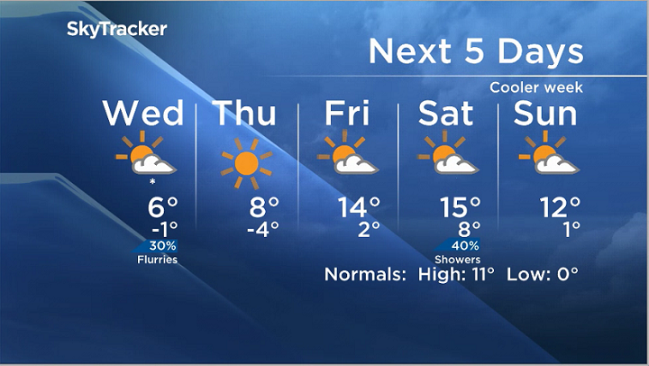


Flurries, a chance of them anyway sit in the forecast for Wednesday and we could still see some showers roll through.
The long range model suggests that we could see normal or above normal temperatures into next week.
More on Canada
- Posters promoting ‘Steal From Loblaws Day’ are circulating. How did we get here?
- Video shows Ontario police sharing Trudeau’s location with protester, investigation launched
- Canadian food banks are on the brink: ‘This is not a sustainable situation’
- Solar eclipse eye damage: More than 160 cases reported in Ontario, Quebec
Comments