
WINNIPEG – A number of watches and warning have been issued as different areas of Manitoba are expected to be hit with thunderstorms, extreme heat and heavy rainfall Monday.

UPDATE: Manitoba tornado lasted ‘incredible’ 2.5 to 3 hours: Environment Canada
A severe thunderstorm watch has been issued for southwestern Manitoba, with a risk of tornadoes; southeastern Manitoba, including Winnipeg, is under a heat warning; and west-central Manitoba has been given a rainfall warning.
LIVE BLOG: Storm chasers gather; risk of tornadoes in Manitoba, Sask.
The severe thunderstorm watch for southwestern Manitoba includes Melita, Boissevain, Turtle Mountain Provincial Park, Killarney, Pilot Mound and Manitou. Storm chasers have gathered in southeastern Saskatchewan, where a tornado watch is in effect for Carlyle, Oxbow, Carnduff, Bienfait and Stoughton, and the weather system is expected to move into Manitoba.
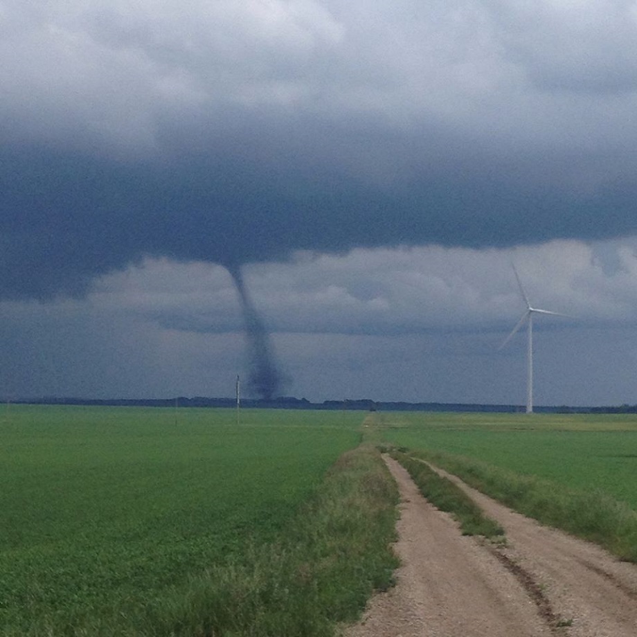
READ MORE: Tornadoes: How do they form?
“Conditions are favourable for the development of severe thunderstorms that may be capable of producing strong wind gusts, large hail and heavy rain,” the alert from Environment Canada states. “Severe thunderstorms can produce tornadoes. Be prepared for severe weather. Take cover immediately, if threatening weather approaches.”
READ MORE: What to do during a tornado warning
Meanwhile, humidex values of 40 are expected Monday afternoon in the Red River Valley and east into Ontario, Environment Canada warns. Temperatures in the 30s plus high humidity will make the temperature feel like 40 or hotter.
READ MORE: Global News weather
Areas under the heat advisory include:
- Winnipeg;
- Portage la Prairie, Headingley, Brunkild, Carman;
- Selkirk, Gimli, Stonewall, Woodlands, Eriksdale;
- Steinbach, St. Adolphe, Dominion City, Vita, Richer;
- Morden, Winkler, Altona, Emerson, Morris;
- Dugald, Beausejour, Grand Beach;
- Bissett, Nopiming Provincial Park, Pine Falls;
- Whiteshell, Lac du Bonnet, Pinawa;
- Sprague; Northwest Angle Provincial Forest; and
- Kenora, Ont.
People spending time in the heat are advised to drink plenty of liquids to decrease the risk of dehydration and guard against heat stroke and head exhaustion. Those especially at risk of heat-related illness include older adults, infants and young children, people with chronic illnesses such as breathing difficulties, heart conditions or psychiatric illnesses, those who work or exercise in the heat and people with no access to air conditioning.


At the same time, heavy rainfall with amounts totaling 50 to 70 millimeters by Tuesday evening is expected in the area from The Pas and Clearwater Lake east to Grand Rapids and Lake Manitoba and south as far as Duck Mountain.
READ MORE: Thunderstorms 101: Derechoes, supercells, multi-cells … what it all means
Rain will develop in Saskatchewan and move into west-central Manitoba beginning Monday evening, the warning from Environment Canada says. Heavy rain is expected to continue through the night and Tuesday, then taper off early Wednesday.
Higher rainfall amounts are possible in some areas and rainfall warnings may be expanded as the weather system develops and moves into Manitoba.
Areas under the rainfall warning at 6 a.m. are:
- The Pas, Wanless, Westray, Clearwater Lake Provincial Park;
- Grand Rapids; and
- Swan River, Duck Mountain and Porcupine Provincial Forest.
To get real-time weather for your area, download the Global News Skytracker weather app.
Comments