
WATCH ABOVE: Montrealers react to the fact that it was the coldest month in history.

MONTREAL – If you thought this month was the most brutal you’ve ever experienced, it wasn’t just your imagination.
Between Ontario and Quebec deep freezes, the Maritime snowpocalypse, and British Columbia’s early spring, February was a month of extreme weather.
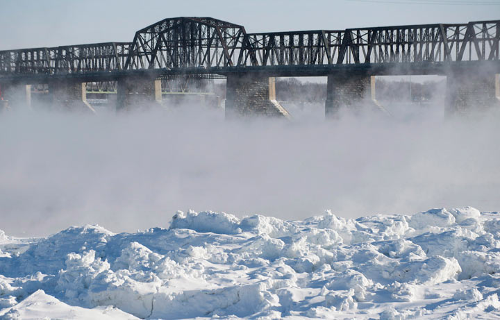
In fact, Environment Canada calls it the coldest February in Quebec history, with an average temperature of -15.3 C, while the daytime normal is actually -7.7 C.
Making it the coldest February since at least 1889.
Other parts of the province fared even worse, with Quebec City reporting a temperature of -17.8 C.
READ MORE: 7 ways to beat the winter blues in Montreal
Ottawa recorded its coldest-ever February as well, with an average temperature of -16.8 C, shattering the former record set in 1979.
In Toronto, it was the first February in 75 years where the temperature did not climb above the freezing mark.
READ MORE: Take heart, Toronto: Warmer weather on the way
Many Maritimers spent most of the month digging out after record snowfalls. Both Halifax and Moncton recorded more than double the average amount of snow for the month.
Charlottetown was buried under more than seven feet of snow (222.8 cm), including nearly 90 cm in a single storm that hit PEI’s capital on February 16th.

By comparison, residents of British Columbia’s lower mainland have had reason to gloat as they experienced weather that was comparatively springlike.
According to environment Canada, the province as a whole was three to five degrees warmer than normal.
READ MORE: Calendar says February but B.C. temperatures say April
Vancouver recorded an average temperature of 7.5 C, with temperatures climbing to 14 C on some days in February.
So who’s to blame?
“The jet stream, which is the fast moving air flow high up in the atmosphere – stayed to our south for most of the month,” explained Global meteorologist, Ross Hull.
“When that happens, arctic air has no barrier stopping it from spilling over southern Quebec.”
Environment Canada meteorologist Maxime Desharnais says it was the persistent cold and wind that set this year apart.
READ MORE: February blahs? Not for everyone across Canada
Now that the worst is over, what can we expect for March?
*With files from the Canadian Press
- ‘Shock and disbelief’ after Manitoba school trustee’s Indigenous comments
- Canadian man dies during Texas Ironman event. His widow wants answers as to why
- Several baby products have been recalled by Health Canada. Here’s the list
- ‘Sciatica was gone’: hospital performs robot-assisted spinal surgery in Canadian first
Comments