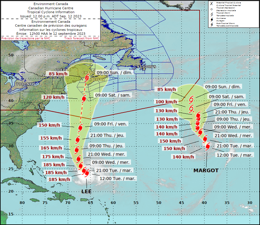
Nova Scotians are preparing for even more rain to cap off a wet summer as Hurricane Lee moves toward Canada’s East Coast.

Global News chief meteorologist Anthony Farnell said heavy downpours are expected Thursday, ahead of the storm, with Lee potentially making landfall in southwestern Nova Scotia Saturday morning.
While the latest Canadian Hurricane Centre track indicates Lee is set to arrive on Sunday, Farnell said there is still “a lot of uncertainty.”
“Because it is about four days away, some computer models are slower, others are faster,” he said.
Ahead of landfall, Farnell said he expects the hurricane to transition to a post-tropical storm with tropical storm-force wind gusts expected “for a very long period of time.”
“Typically, you get these hurricanes or tropical systems that move through very quickly, within six to eight hours. This time around, it’s actually going to be slowing down, so some areas could see tropical storm-force winds for about 24 hours time, which means a lot of battering waves for the coast, a lot of rain falling as well, and potentially power outages,” Farnell explained.

Get breaking National news
“So, all of that on the table this weekend, and then the system will weaken as it moves up towards P.E.I. on Sunday.”
There is still some uncertainty about if the storm will make landfall in Nova Scotia, because if it continues to slow down, it’s more likely to push back toward New England instead.
However, “right now, the most likely outcome is a Saturday landfall in southern Nova Scotia,” Farnell said.
Farnell said the incoming rain is a concern for the province, which has already seen a record amount of precipitation over the summer.
The rainy weather combined with few recent wind events means there is still a lot of foliage on the trees, making them prone to wind damage and more likely to be knocked over, causing power outages.
But in terms of expected damage, the meteorologist said Lee is “not a repeat” of previous historic storms, like post-tropical storm Fiona last year and Hurricane Juan 20 years ago.
“This has a large wind field, it will cause some damage, but I don’t think it will rival either of those storms as we go through the weekend,” he said.
“But still, some things can change and we have to take every (storm) seriously.”
Lee is the 12th named storm of the Atlantic hurricane season, which runs from June 1 to Nov. 30 and peaked on Sunday.
Tropical Storm Margot became the 13th named storm after forming Thursday evening, but it was far out in the Atlantic and posed no threat to land.
The National Ocean and Atmospheric Administration in August forecast between 14 and 21 named storms this season. Six to 11 of them are expected to become hurricanes, and of those, two to five might develop into major hurricanes.


Comments
Want to discuss? Please read our Commenting Policy first.