

The summer season is here and the forecast is looking hotter than normal for much of Canada. We are still in a very “blocky” pattern that features a large upper-level ridge in the middle of the country. This has been an almost constant feature since the end of April and has led to record heat and extremely dry conditions as it oscillates back and forth from west to east.

Will this be the summer of fire and smoke across Canada?
The blocking high is the main reason for a historic start to the fire season, in which millions of acres have burned in the west, the largest fire in Nova Scotia history continues to burn, and now dozens of lightning-induced wildfires are raging through Quebec.
Smoke-filled skies have filtered the sun’s rays and reduced air quality at times from B.C. all the way to Newfoundland and Labrador. High-temperature anomalies and low humidity will remain across the north for at least the next couple weeks before the ridge finally breaks down.
Side note: These blocking patterns are notorious for lingering longer than expected and computer models sometimes struggle with how everything evolves. Even after the block breaks down, smoke and northern wildfires will likely be with us through the summer months which could lead to one of the most active years on record.

-
![]() Wildfires in Nova Scotia decrease amid continuous downpours
Wildfires in Nova Scotia decrease amid continuous downpours -
![]() Saint John, N.B., keeps burn ban in place despite province lifting restrictions
Saint John, N.B., keeps burn ban in place despite province lifting restrictions -
![]() Quebec wildfires prompt over 10,000 people to evacuate
Quebec wildfires prompt over 10,000 people to evacuate -
![]() Nova Scotia wildfires: Fire outside Halifax now considered ‘under control,’ official says
Nova Scotia wildfires: Fire outside Halifax now considered ‘under control,’ official says -
![]() Nova Scotia wildfires: Rain brings relief to region, firefighters
Nova Scotia wildfires: Rain brings relief to region, firefighters


Another factor that will play an increasing role in the global weather pattern later this summer and into the winter is the developing El Niño. After three years of cool water near the equator (La Niña), the easterly trade winds are increasing which piles up warm surface water off the South American coast. That impacts the jet stream and the weather pattern around the entire planet.

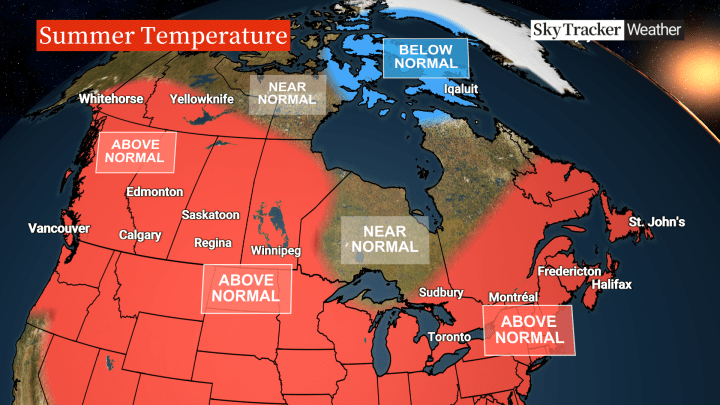
Here’s what to expect across Canada this summer:
B.C. and Alberta
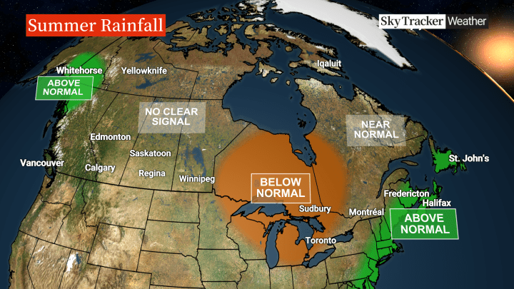
A warmer-than-normal summer is likely across these two provinces with the hottest temperatures occurring in July. It’s been a very dry start to the season across southern B.C. and northern Alberta but most areas will return to a more typical rainfall pattern in the months ahead with mostly afternoon showers and thunderstorms.
Frequent frontal systems will bring above-normal rains to the far north extending into parts of Yukon. After a very early start to the fire season in northern B.C. and Alberta, recent rains are helping and near-normal fire activity is likely for the next few months.
Saskatchewan, Manitoba and northwest Ontario
Above-normal temperatures are likely to continue right through the summer with times of higher humidity levels. Winnipeg just had its fifth warmest May on record and June is off to a scorching start. Look for the extreme heat to back off in the weeks ahead.

Get breaking National news
Recent rains have been heavy across southern Saskatchewan and Manitoba but computer models have mixed signals when it comes to how much rain will occur over the next couple of months. There are signs that it will be drier than normal for parts of northwest Ontario.


Southern Ontario and Quebec
It’s been a very dry second half of spring in Ontario with signs of a minor to moderate drought developing in some areas like southwest Ontario. It’s also been drier than normal across most of Quebec and with recent lightning strikes, fires are raging across central parts of that province. Smoke from those fires will continue to influence the weather in the weeks ahead until significant rain arrives.
Unfortunately, drier-than-normal conditions are expected to continue for much of the upcoming summer. Big swings in temperature will keep it near seasonal across the north but leaning hotter than normal for southern Ontario and southern and eastern Quebec. I don’t expect the same long-lasting heat waves as in past years and fewer 30 C days are expected.
Atlantic Canada
It was a very dry spring across the Maritimes but the rains have finally arrived and the cool and wet pattern looks to continue through at least the middle of June. This has already given firefighters the upper hand in battling blazes burning in Nova Scotia and will reduce the fire risk in the months ahead.
It looks like a wet summer across the region with above-normal rain extending all the way through Newfoundland. Temperatures will also rebound after the cooler June with a warmer-than-normal July and August.
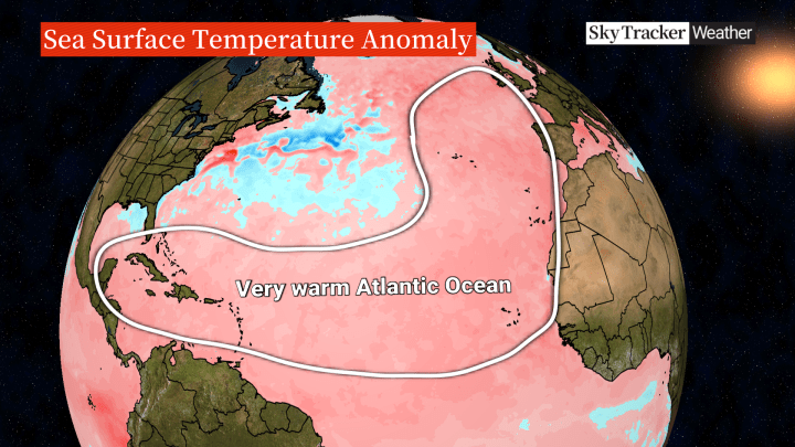
There is some cooler-than-normal water off the east coast but as a whole, the Atlantic Basin is warmer than it’s ever been at this time year, which could lead to an active hurricane season. The developing El Niño is the main reason why hurricane forecasters aren’t calling for even more activity as often El Niño patterns include more wind shear, which can tear tropical storms apart.
Northern Canada
The blocking pattern has led to a very early start to the fire season in the Northwest Territories and record-high temperatures are being set in many locations north of the 60th parallel.
A turn to more typical summer conditions is likely later in June and July but with a warmer-than-normal signal for southern areas. Colder-than-normal temperatures are favoured in parts of Nunavut back towards Greenland.
Comments
Want to discuss? Please read our Commenting Policy first.