
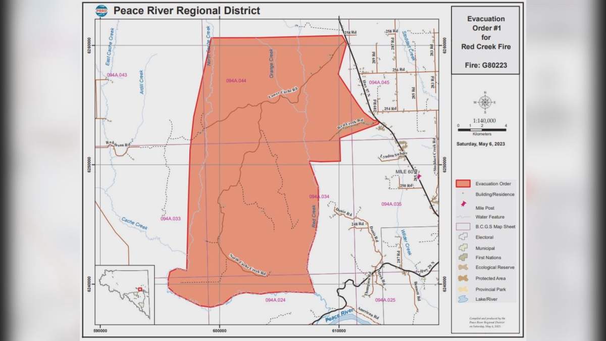
The Peace River Regional District issued an evacuation order for the Red Creek and Lower Cache areas northwest of Fort St. John.

The order was issued due to the 1,550-hectare Red Creek wildfire, which is burning out of control, Saturday afternoon.
The evacuation order is in effect for the following areas:
- From a point 0.75km south of the intersection of the Red Creek Road and Highway 97N headed southwest to a point of intersection of the Red Creek
- Following the Red Creek south to Cache Creek
- Following the Cache Creek west to the North Cache Creek
- Following the North Cache Creek north to a point due east of 258 Road Due east to Highway 97N
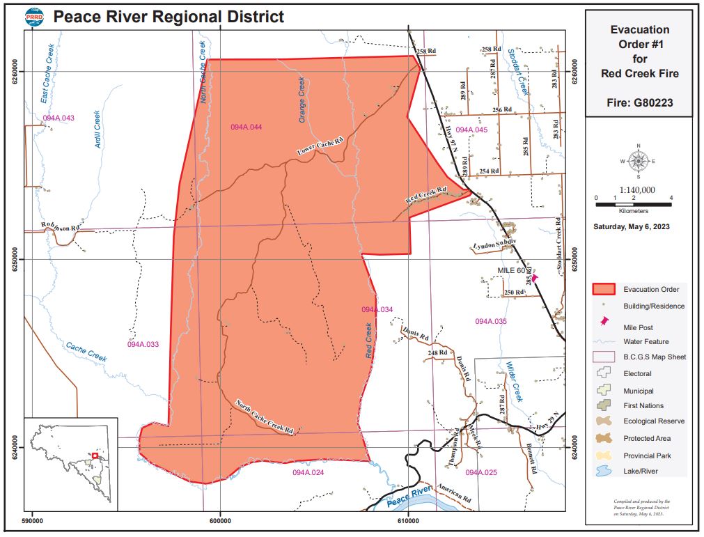
Sixty-one properties in the area are also under the evacuation order. For a full list of addresses, the order can be read online.
Mounties are assisting in the evacuation of residents, according to the regional district.

Get breaking National news
An evacuation alert has also been issued for some properties in the area.
The Peace River Regional District has issued evacuation alert for the Red Creek wildfire for properties in the Red Creek, Lower Cache and south of the Beatton Airport Road areas as follows:
- From the intersection of Highway 97 N and Beatton Airport Road, heading north along Highway 97 N to 258 Road
- Heading west beyond North Cache Creek
- Heading northeast to Fox Creek
- Due west to the Prespatou Road
- Follow the Prespatou Road south to 256 road
- Following 256 Road west to 281 Road
- Following 281 Road south to 254 Road
- Following 254 Road to Highway 97N
- As well as the area 5.5km west of Highway 97N and 4 km north of Lyndon subdivision

If you are an evacuated resident, the regional district is urging people to:
- Follow the Red Creek Road or Lower Cache Road east to Highway 97N and continue to Fort St. John
- Proceed the to Emergency Support Services reception centre located at North Peace Arena, 9805 96 Avenue, Fort St. John, B.C., and if the reception center is closed, please call 250-794-3310
- If you need transportation assistance from the area, call 1-800-670-7773
- Shut off all gas and electrical appliances, other than refrigerators and freezers
- Close all windows and doors
- Close gates (latch) but do not lock
- Gather your family and, if you have room, take a neighbour or someone needing transportation
- Do not use more vehicles than you have to
- Take critical items (medicine, purse, wallet, cell & charger and keys) only if they are immediately available
- Take pets in pet kennels or on leash
- Do not use the telephone unless you need emergency service
- New wildfire near Boston Bar prompts evacuation of entire area
- For 1st time in Canada, drones are being used in B.C. wildfire response
- Ontario grounds 2 waterbombers for repairs as wildfires rage through north
- Hundreds of British Columbians watching wildfires closely as they burn close to communities


The Red Creek wildfire was first reported in the afternoon on May 5, and four attack crews, a unit crew, and a helicopter were assigned to the blaze. A second helicopter is now assisting as well.
“A wind warning is in effect for the Peace region. Sustained winds of 25-45km/hr are forecasted for (Saturday) afternoon, with gusts reaching 60km/hr,” BC Wildfire officials said in their report. “Extreme fire behaviour is anticipated on existing fires and new fire starts are expected to grow rapidly.”
Heavy smoke in the area is making it challenging for crews and is affecting aviation resources.
Community members are encouraged to stay up to date on the regional district’s alert webpage.
The Red Creek wildfire is suspected to be human-caused.
Comments
Want to discuss? Please read our Commenting Policy first.