

There’s still “significant uncertainty” regarding the track of a storm that’s set to hit southern Ontario later this week, but heavy snow amounts are likely for most of the region, Global News meteorologist Anthony Farnell says.

Farnell said the storm, which will move in on Friday, will be the third snowfall in less than 10 days and will likely be the heaviest of the three for most of southern Ontario.
“Snow mixed with rain begins across southwest Ontario during the early afternoon on Friday and then spreads into the GTA before dinner,” he said.
“The heaviest snow will be during the late evening through very early Saturday morning with rates of 3 to 4 cm per hour likely for a time.”
Farnell said that’s when winds from the east, that could gust as high as 80 km/h, will be the strongest, causing blowing and drifting snow and reducing visibility to near zero.
“By Saturday morning, only light snow or rain is likely, but by that point it will once again look like a winter wonderland outside,” Farnell said.
He said while it’s still early and details may change before Friday, snowfall amounts will likely range from 15 to 20 cm around the Greater Toronto Area with the potential of up to 30 cm in some areas north and west.
“Temperature will once again play a critical role in exactly how much snow falls on the region,” Farnell said.
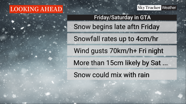


“With the mercury within a degree or two of freezing, the snow will likely become heavy and wet as the storm progresses with a transition to rain also possible for areas closer to Lake Erie and Lake Ontario.”
Milder temperatures will move in on Saturday and especially Sunday, meaning the snow will quickly begin to melt.
But areas further north and east of the GTA will see a bit cooler weather, “which is great news for skiers and winter weather enthusiasts hoping for some fresh powder,” Farnell said.
He noted that the weather system is the same one that has brought “incredible” amounts of snow to California, Utah and even Arizona.

Comments