
Daily high temperature records were broken across southern Ontario on Wednesday as unusually warm weather continues this winter.

While some records were also broken on Tuesday, Wednesday’s record highs were more widespread.
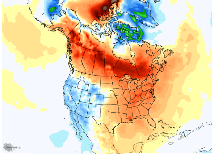
“The unusual warm weather was pushed north by a system that took an usual track for this time of year up across Lake Superior towards Hudson Bay,” Global News meteorologist Anthony Farnell said.
“Normally snow cover would ‘chill’ this unusually mild airmass before it reaches the Great Lakes, but there is no snow to be found across much of southwestern Ontario or across the Ohio Valley in the U.S. In fact, for the first month and a half of 2023, almost all of Canada and the northern U.S. have experienced well above normal temperatures.”
Here are some of the new record highs for Feb. 15 observed in southern Ontario Wednesday, according to Environment Canada:
- Toronto Pearson: 15 C (Old record was 12.2 C set in 1954)
- Hamilton: 15.2 C (Old record was 8.9 C set in 1976)
- Kitchener-Waterloo: 13.8 C (Old record was 10 C set in 1954)
- London: 14.2 C (Old record was 11.7 C set in 1954)
- Peterborough Airport: 11.8 C (Old record was 7.2 C set in 1976)
- Kingston: 12.2 C (Old record was 7.2 C set in 1976)
- Ottawa International Airport: 9.6 C (Old record was 6.7 C set in 1954)
But will the warmer-than-normal weather last?
Farnell said there are signs “we are far from done with winter” as the polar vortex gets disrupted over the Arctic, bringing cold and snow back to areas that have been experiencing spring-like weather recently.
“The pattern looks to turn colder than normal for the end of February through at least the first part of March,” he said.
“The big question is what happens after that?”
Farnell noted that in recent years, cool weather has lingered into April causing a delayed start to spring. He said that is something that may happen again this year, but it’s not yet clear.
“This winter has been one of the least predictable I can remember so I’m not willing to go out on a limb on any forecast out further than a week or two,” he said.
In the short term, parts of southern Ontario are under a freezing rain warning, including parts of the Greater Toronto Area, Hamilton, London and Kingston, with a “wintry mix of precipitation” expected Thursday night, Environment Canada said.


Comments