
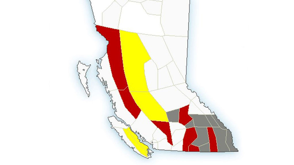
A wide variety of weather alerts have been issued across parts of B.C.

In the Southern Interior, heat warnings are in effect for the Fraser Canyon and South Okanagan plus the Boundary, Kootenay Lake and North Thompson regions.
Temperatures in those areas are expected to reach daytime highs in the low- to mid-30s, as a strong ridge of high pressure continues to bring heat to those areas.
How long the heat warning will be in effect isn’t known, with Environment Canada saying “unsettled weather and slightly cooler temperatures are forecast beginning late today as a series of disturbances cross the region.”

Elsewhere in B.C.’s Interior, air quality statements because of wildfire smoke are in effect for the following regions:
- 100 Mile House
- Arrow Lakes
- East Columbia
- East Kootenay
- Elk Valley
- Kootenay Lake
- Shuswap
- West Columbia
- West Kootenay
- Yoho Park / Kootenay Park

Get breaking National news
“Wildfire activity over the past 24 hours has contributed to increased haze and smoke over sections of southeast B.C.,” said Environment Canada.
In related news, the BC Wildfire Service said there were 491 lightning strikes on Thursday. Below are the number of lightning strikes per fire zone.
- Cariboo Fire Centre: 185
- Coastal Fire Centre: 131
- Kamloops Fire Centre: 50
- Northwest Fire Centre: 125
- Prince George Fire Centre: 0
- Southeast Fire Centre: 0


Heat warnings are also in effect for the Central and North Coast regions, where daytime highs near 30 C are expected.
“Elevated temperatures continue for inland regions of the north and central coasts of British Columbia,” said Environment Canada. “A ridge of high pressure over the region will remain in place through the weekend and into early next week.
“Another round of hot weather is expected to redevelop next Wednesday and continue for the remainder of next week.”
And, lastly, a severe thunderstorm watch is in effect for the Chilcotin and Bulkley Valley in the Central Interior.

Comments
Want to discuss? Please read our Commenting Policy first.