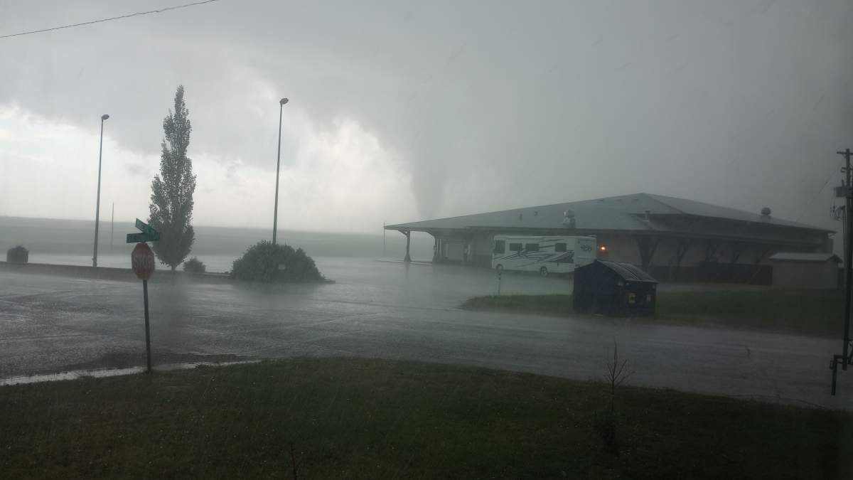
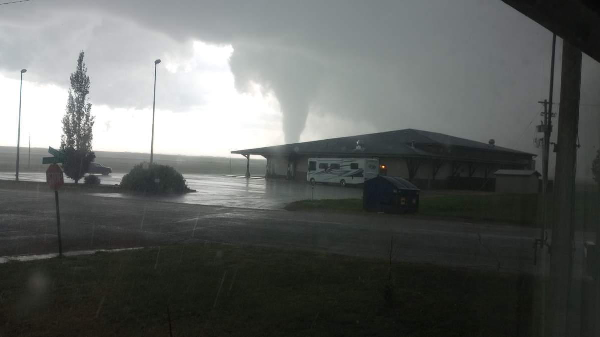
Environment Canada confirmed there was a tornado Sunday at about 5:10 p.m. five kilometres southwest of Coronation, Alta.

The weather agency has given the tornado a preliminary rating of EF0.
“This is our seventh tornado that we’ve confirmed this year,” said Kyle Fougere, a meteorologist with Environment and Climate Change Canada.
“There are a number of other tornados that remain under investigation so it’s likely that number will rise as we move through the summer. We’re not done with our severe weather threat.”
He said there are severe thunderstorm warnings and watches in Alberta on Monday too.
“It is the long weekend and we do have severe thunderstorm risk in the area,” Fougere said. “It’s possible that even tornado watches could be issued today.
“So as people are out and about, just make sure they have a way to get our reports, through a cell phone, they can download our WeatherCAN app and the Alberta Emergency Alert should severe weather threaten.
“Have a plan of action… so they can prevent injury from storms if they arrive,” he said. “Know where to go… the most sturdy building around. Put as many walls between you and the severe weather. If you’re in a house, try to get as low to the ground as you can and put as many walls as you can between you and the tornado.”
Leslea Herber lives in Coronation, about 315 kilometres southeast of Edmonton, and saw the alert on her TV Sunday evening.
“When that happens, I make a point of looking outside to see if it’s here and if I can see it. That way I know whether I can relax or if I have to run like hell to my neighbour’s place where they have a basement.
“I looked outside and I saw the funnel cloud and I’m like: ‘Oh dear…’
“I watched it for a few minutes, saw that it was heading away from town (and) let out a rather large sigh of relief.”
Herber said it was “deeply concerning” to see a tornado that close.
“I could see the funnel cloud coming down. The bottom was obscured by the local community centre, so I couldn’t see the actual touchdown and I didn’t want to go outside because there was hail the size of loonies coming down.”

Get daily National news
Herber said her neighbour saw two funnel clouds that evening, and saw the larger one touch down. His house suffered some damage, but it’s not clear if it was from the wind, hail or tornado, she said.
“I could see it dissipated… After it cleared up, it was crazy how fast it went from insane apocalyptical weather to sunny again.
“We’re very lucky that hit out in the middle of the field rather than up in the dam where there’s a rodeo happening this weekend.”
Herber said she’s seen dust devils before, but this is the first time she’s witnessed a tornado.

While there were multiple reports and photos of the tornado, there have been no reports of damage “at this time,” Environment Canada said Monday morning.
The tornado warning was issued for the Town of Coronation just after 5 p.m. and it lasted for about an hour.
Warnings were also issued for Flagstaff County (at around 4 p.m.) and the County of Paint Earth (near Castor). Both warnings were in place for about an hour.
Later Sunday, at around 9:45 p.m., another tornado warning was issued for Clearwater County, west of Red Deer, which was in place for about half an hour.
Read more: Storm that triggered tornado warning rips off roofs, uproots trees in northern Alberta village
The storm made its way southeast.
According to the Alberta Emergency Alert website, the critical alert was triggered by “a rotating severe thunderstorm that is possibly producing a tornado.”
The agency said the storm was located “15 kilometres east of Castor, moving southeast at 40 km/h.”
Golf ball-sized hail was reported, AEA said.
Herber said they were compact, loonie-sized, like little ice cubes.
“The road in front of my place was literally a river. You could have taken a kayak down there.”
All alerts were dropped by 10:17 p.m.
- Prairie Lily’s sailing season stalled by late thaw in northern Saskatchewan
- Bear warnings issued for Kananaskis Country after 2 people bluff charged
- 14 flood-related local emergencies declared in 48 hours in Saskatchewan: SPSA
- Canadian Natural president says oil sands growth depends on new West Coast pipeline
“We have had a very active period of weather over this long weekend, which is pretty typical for this time of year,” Fougere said.
“July is when we see our peak thunderstorm season in our province and we do get a lot of severe weather reports.”
Late July and early August usually create conditions that fuel thunderstorm formations and even tornados, Fougere said.
“We have a lot of moisture in the province and we tend to get a lot of ridges of high pressure this time of year, which brings in the heat. With that heat and the humidity, you have the potential energy that’s necessary for these thunderstorms. When you get a low pressure system that can bring some strong winds to mix into that, that’s when we get our really severe thunderstorms.
“On average, Alberta sees about 12-15 tornados per year, so we’re still a little on the below average side, but there’s still quite a bit of the season left.”
In 2019, Alberta reported 23 tornados. In 2020, that number was 17. Fougere said 2021 was a rare low year, with just three tornados reported in Alberta, which he credits to the La Nina year, which made the summer cooler and wetter than usual.
Environment Canada fields more than 100 reports in an average summer for Alberta and issued more than 1,500 watches and warnings.
Severe thunderstorm activity and tornado reports tend to tail off in mid-August, Fougere said.
“Sometimes we do receive reports as late as October. So it’s unlikely we’re done with the season yet but it should slow down as we move into the month of August.”
The Coronation tornado happened exactly 35 years after the deadly Black Friday tornado in Edmonton.
However, Fougere said because of the low population density in Alberta, most tornados touch down where there’s nothing to hit.
But people, especially in Edmonton, are reacting to the memory of the 1987 tornado. And alerts can be a trigger, Fougere said.
“It still feels like in the community there’s that lingering effect that people really do take these warnings and watches very seriously and have a plan of action in place, which is great to see.”
For the latest Environment Canada alerts, click here.

Environment Canada said hot conditions across southern Alberta broke some temperature records.
The following areas set a daily maximum temperature record on July 31, 2022:
Bow Valley (Provincial Park) Area (Bow Valley)
New record of 33.7 C
Old record of 32.2 C set in 1973
Records in this area have been kept since 1928
Milk River Area (Milk River)
New record of 35.1 C
Old record of 34.5 C set in 2005
Records in this area have been kept since 1994
Waterton Park Area (Waterton Park Gate)
New record of 32.5 C
Old record of 31.8 C set in 2015
Records in this area have been kept since 1976


Comments
Want to discuss? Please read our Commenting Policy first.