
Tired of snow? And especially shovelling it?

Well, a solid break from cold temperatures is en route, according to Environment Canada.
The national weather agency is calling for temperatures well above 0 C for the next few days, with the mercury reaching 6 or 7 C by Monday throughout the Okanagan.

However, for Friday, Environment Canada is calling for 2-4 cm of snow, along with a high of 0 C, 15 km/h winds, a windchill of -6 in the morning, and an overnight low of -2 C.
Following that, sunny skies are projected for Saturday, along with a high of 5 C and a low of -1 C.
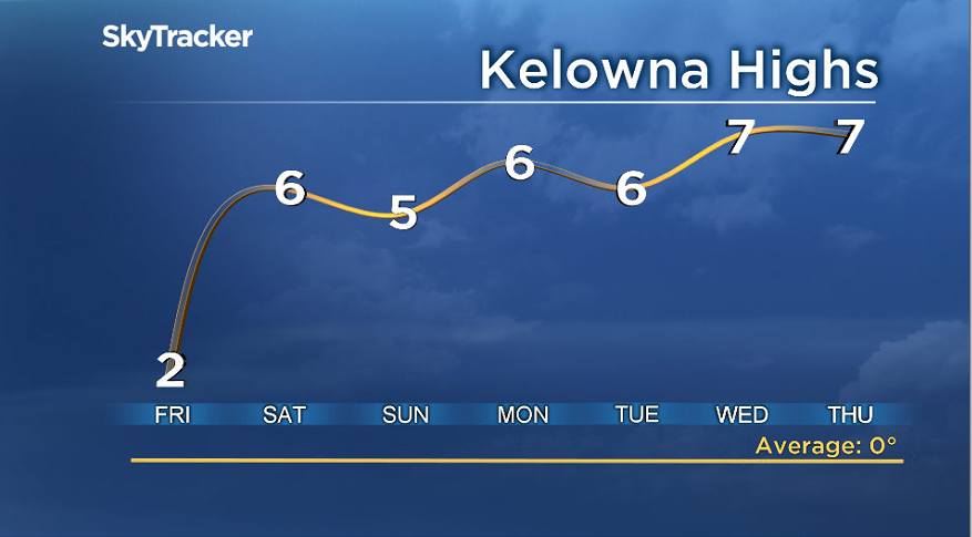
For Sunday, a mix of sun and cloud is in the forecast, plus a high of 4 C and a low of 1 C.

Get breaking National news
For Monday, another mix of sun and cloud is projected, along with that high of 6 or 7 C. By night, clouds are expected to roll in, with the mercury falling to -2 C.
- Banff monitoring Bow River for flooding amid heavy downpour, snowpack melt
- Smoke, heat, rain and flooding; what to expect from Western weather
- A month’s worth of rain coming to Edmonton, parts of Alberta in next few days
- With days of heavy rain in the forecast, southern Alberta prepares for flooding


Cloudy skies are predicted for Tuesday and Wednesday, with highs of 4-5 C and lows of -2 C.
For the Shuswap, the forecast is mostly the same, though Monday’s high for the Salmon Arm area is projected to be 4 C.
The normal temperatures for this time are 0 C and -6 C.
For mountain passes, the forecast is calling for snow possibly becoming mixed with rain on Friday, for the Coquihalla Highway, and for flurries / snow on the Okanagan Connector and Highway 3. The projected snow levels are 2-5 cm.
Comments
Want to discuss? Please read our Commenting Policy first.