

Environment Canada has added snowfall to its list of weather warnings for parts of British Columbia, as bitterly cold temperatures persist in much of the province.

Five centimetres of snow is forecast for the central coast and 10 cm is forecast for the inland sections of the central coast, including Bella Coola and Hagensborg.
On Vancouver Island, the Southern Gulf Islands, in Metro Vancouver, the Fraser Valley and along the Sunshine Coast, between five and 10 cm is expected.
The snow is expected to taper off on Thursday as a storm system moves across the South Coast.
Heavier amounts — between 10 and 15 cm — could fall in the Central Interior, including the Cariboo, 100 Mile House, Muncho Lake Park-Stone Mountain Park, Prince George, Teslin, Stuart-Nechako and Watson Lake areas.
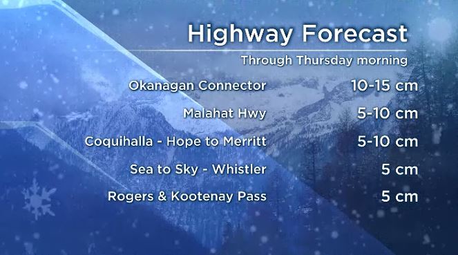
That, too, is expected to taper off between Wednesday afternoon and Thursday morning.

Get breaking National news
Meanwhile, extreme cold warnings remain in place for much of the province.
Environment Canada warns wind-chill values of -35 or lower are possible Wednesday and Friday in the Fraser Canyon, Similkameen, Nicola, Shuswap, South Thompson, North Thompson, East Columbia, North Columbia, Elk Valley and Kinbasket regions.
It could drop below -40 on Wednesday and Friday morning in the Cariboo, Chilcotin, Prince George, Stuart-Nechako, Yellowhead, McGregor, Williston, Peace River and Bulkley Valley regions plus the Lakes District.
Read more: Cold weather here for ‘long haul’ but heavy Manitoba snow has some positives: climatologist
The East Kootenay and Elk Valley areas can expect -35, with light to moderate winds on Wednesday. Those values will also persist in Yoho-Kootenay Park from now until Friday.
“Frostbite can develop within minutes on exposed skin, especially with wind chill,” the federal department warns.
“Watch for cold-related symptoms: shortness of breath, chest pain, muscle pain and weakness, numbness and colour change in fingers and toes.”


Arctic outflow warnings remain in place for inland sections of the central coast, which can expect wind-chill values between -20 and -30 between now and the end of December.
In Metro Vancouver, plus the Fraser Valley, Howe Sound, the Sea to Sky Highway, Whistler and the mainland inlets of the Sunshine Coast, the wind chill will be near or below -20, but will moderate on Wednesday as winds ease.
On Tuesday, the cold temperatures had some Metro Vancouver residents out skating on local lakes and ponds, but the Vancouver Parks Board has warned recreationalists against it.
It may look safe, it tweeted, but looks can be deceiving.
The cold conditions have recently prompted the Fraser Health Authority to reduce services at a number of its vaccine and immunization clinics.
On Wednesday, testing remains available until 4 p.m. at the Langley, Coquitlam, Surrey 66 and Burnaby COVID-19 Testing and Immunization Centres.
Immunizations, however, have been suspended at the Langley, Coquitlam, Surrey 66, and Burnaby COVID-19 Testing and Immunization Centres.
Comments
Want to discuss? Please read our Commenting Policy first.