Advertisement

B.C. floods from the air: Aerial photos and videos show devastation

Click to play video: 'B.C.’s Coquihalla Highway seen from the air shows extent of the damage'
B.C.’s Coquihalla Highway seen from the air shows extent of the damage
WATCH: Flying over B.C.'s Coquihalla Highway Tuesday morning, the damage from the deluge of rain is very evident and shocking. The road has been completely snapped in two and a timeline for when it may reopen remains unclear at this time – Nov 16, 2021

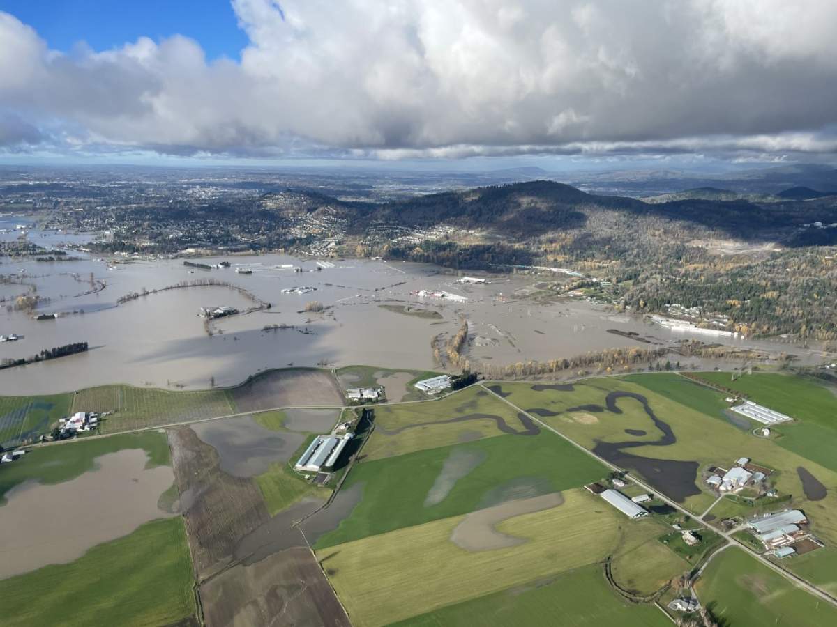
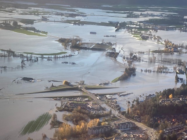
The catastrophic damage from the recent B.C. storm is still being assessed but the devastation is clear.

Roads are underwater, cars swept away and homes lost.

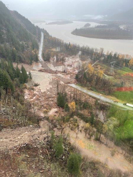
Photos and videos taken from the air highlight how much the atmospheric river affected so many parts of the province.

Click to play video: 'From the air: The extent of the flooding in the Whatcom Road area of Abbotsford'
From the air: The extent of the flooding in the Whatcom Road area of Abbotsford

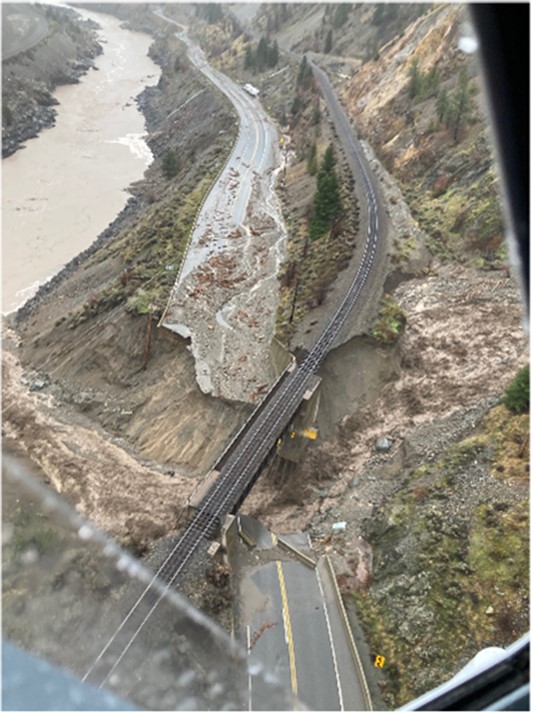
From the air it is clear to see a section of the Coquihalla Highway is gone, snapped in two, and it could be weeks or even months before it reopens.

Story continues below advertisement
The Sumas Prairie from the air on Tuesday. Global News
Popkum from the air as seen on Tuesday morning. Global News

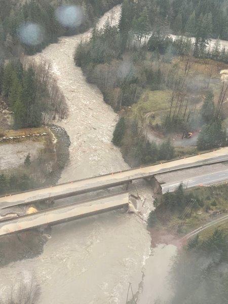
This video shows the damage along Highway 1 near Popkum, east of Chilliwack.

Story continues below advertisement

The debris slide has completely covered the road and crews are on scene working to clear it as fast as possible.

Click to play video: 'From the air: A closer look at the landslide on Highway 1 near Popkum'
From the air: A closer look at the landslide on Highway 1 near Popkum
A stretch of Highway 1 through Abbotsford Tuesday morning. Drive BC
Assessing damage at Ruby Creek. B.C. Ministry of Transportation
Flooding on Highway 11. B.C. Ministry of Transportation
Highway 1 at No. 3 Rd near Chilliwack. B.C. Ministry of Transportation
Highway 1 in the Fraser Valley – Aerial of damage to the Patterson Creek area. B.C. Ministry of Transportation

Video taken from the slide on Highway 99-Duffey Lake Road shows trees covering the highway and cars swept down the embankment.

Story continues below advertisement

One woman was killed in the slide and at least two others are missing.

A Global BC cameraman was swept up in the slide and described what he saw.

“I turned around and looked at my truck and it was half-buried and all the cars that were on the road and all the people, they were just gone,” Mike Timbrell said.

Click to play video: 'From the air: A look at the slide along Highway 99-Duffey Lake Road north of Pemberton'
From the air: A look at the slide along Highway 99-Duffey Lake Road north of Pemberton
Whatcom Road Interchange in Abbotsford.
Whatcom Road Interchange in Abbotsford. B.C. Ministry of Transportation
Highway 1 – Tank Hill in the Fraser Canyon
Highway 1 – Tank Hill in the Fraser Canyon. B.C. Ministry of Transportation
Washout on Highway 5 near Carolin Mine Road
Washout on Highway 5 near Carolin Mine Road. B.C. Ministry of Transportation
Aerial view of slide impacting BC Highway 7 near Seabird Island
Aerial view of slide impacting BC Highway 7 near Seabird Island. B.C. Ministry of Transportation

Sponsored content

AdChoices