

I would argue the fall forecast for Canada this year is more important than ever before.

Coronavirus numbers are already starting to creep up across the country and with the prospect of a second wave on everyone’s mind, warm and sunny late season weather would go a long way in keeping people outdoors in backyards, parks and patios.
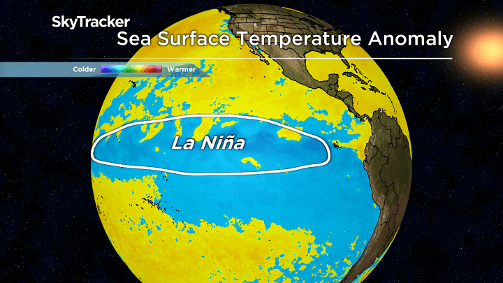
We have already had an early taste of fall across much of Canada. Record cold earlier this month ended the growing season in Saskatchewan, parts of Manitoba and Alberta. Cool shots of air have also been felt in Ontario through Atlantic Canada with more on the way the second half of September. Is this a sign of what’s ahead or are we going to get a long second summer like we’ve seen in the past? There is also a developing La Niña that will inevitably play a role in the weather pattern, especially later this fall and winter.

Here’s a detailed look at what to expect this fall.
Atlantic Canada
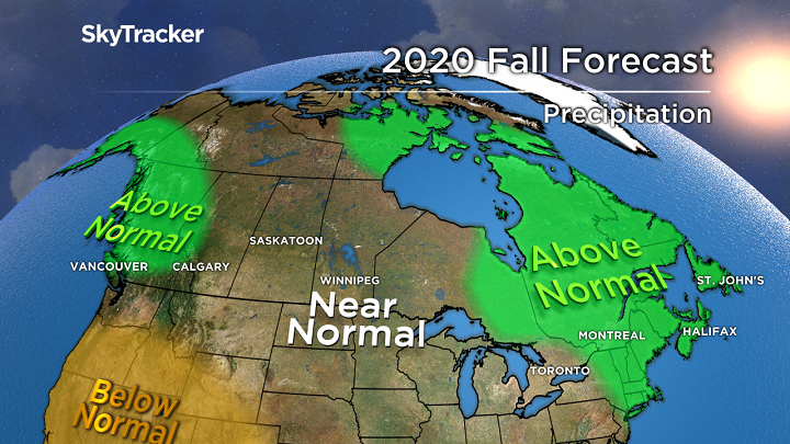
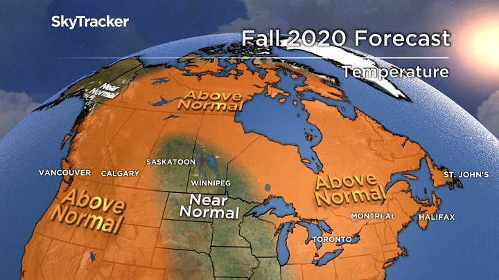
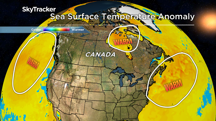
After a warm and very dry summer, cooler conditions are finally starting to settle in. A back and forth pattern will keep temperatures only slightly above normal for the rest of September but I’m expecting a mild October and November thanks in part to the very warm water surrounding Atlantic Canada. This warm water would also play a role in maintaining the intensity of any tropical storms or hurricanes that head north. It’s been an incredibly active season and a switch over to the Greek Alphabet is all but certain. I would be very surprised if one or two storms didn’t impact the Maritimes or Newfoundland this season. The good news would be the much-needed rain that came with any tropical systems.
Ontario and Quebec

Get daily National news
It was one of the warmest summers on record for this region including an all-time record hot July in places like Toronto. The heat and humidity also played a role in the very active tornado season with almost double the average number of twisters. In September, frequent cold fronts have been a reminder that the seasons are in fact changing. Warm and cool will battle it out for the second half of the month, leading to seasonal temperatures and rainfall. October will be a mild month but November could turn wild as a more active La Niña storm track gets established. This will lead to above normal rainfall around the Great Lakes and into Quebec. The active weather pattern should continue through much of the winter.
Prairie Provinces
Occasional frosty mornings will become more frequent in the weeks ahead but that’s not surprising for this part of Canada. The pattern favours equal above and below normal days through September with this trend continuing for much of fall in Manitoba and Saskatchewan. This is one of the few spots in the country where I’m forecasting a seasonal fall with near-normal precipitation. Enjoy the relative calm because a La Niña pattern December through the rest of winter would mean plenty of cold and snow.


BC
The western ridge has been impressive all September with glorious late summer weather for much of BC. Unfortunately that same ridge has lead to frequent forest fires south of the border including some of the biggest on record in Oregon and Northern California. Smoke from these fires is slowly dispersing but poor visibility and air quality will remain a risk at times in the weeks ahead. Temperatures will remain above normal for much of fall but I’m also forecasting above normal rainfall. Much of this will occur in November and December as the La Niña winter pattern begins to take shape. Mountains locations are in for a great ski season with plenty of early snow to build a base leading into the holidays.
Yukon, NWT and Nunavut
Water temperatures across the far north remain well-above normal and should delay the onset of ice. This will also keep milder than normal temperatures around through much of fall. Keep in mind that even with a “mild” pattern, plenty of snow will fall in this area as days quickly get shorter. Colder than normal air is more likely across the west over Yukon late this fall and winter.
Winter Preview
Get ready for a wild winter. No two La Niña’s are alike but the trend would be to have colder than normal temperatures out west and a milder pattern in the east. La Niña’s often have a stronger than normal polar jet stream which would bring more snow to the west and a parade of storms bringing everything but the kitchen sink to the Great Lakes and Atlantic Canada. Stay tuned…
Comments
Want to discuss? Please read our Commenting Policy first.