

Usually this time of year the spring melt is top of mind in southern Manitoba.

This year is obviously different, but when every precipitation event can change the flood forecast, southern Manitoba is missing out on a substantial snow event that will pass by to the north.
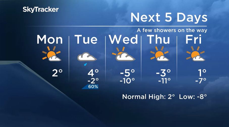
Temperatures have started to moderate a bit after a cool week.
Temperatures will start close to normal this week but cool off temporarily after a significant low-pressure system moves through the province. Central Manitoba could see snowfall warnings issued by Environment and Climate Change Canada as 10-15 cm is likely to fall through Tuesday.

Meanwhile, around southern Manitoba the precipitation will be much less. Around Winnipeg, showers are likely with around 1 mm falling on Tuesday.


Get breaking National news
Winds will be noticeable ahead of this system and while it’s moving across the province. Monday will see winds around Winnipeg at 30 km/h, gusting to 50 km/h, and Tuesday could be stronger with gusts near 60 km/h possible, thanks to a passing front.
Behind this system, temperatures will cool off temporarily but should be back above 0 C by the weekend.
Comments
Want to discuss? Please read our Commenting Policy first.