

It was a very mild start to March in Winnipeg, but as much as there have been a number of days where the snow been melting, the amount of snow on the ground has actually grown.


At the beginning of the month, the Environment and Climate Change Canada site that tracks snow depth in Winnipeg measured 25 centimetres on the ground. So far this month, as of March 13, 14 centimetres of snow has fallen and the snow depth is up slightly to 28 centimetres.
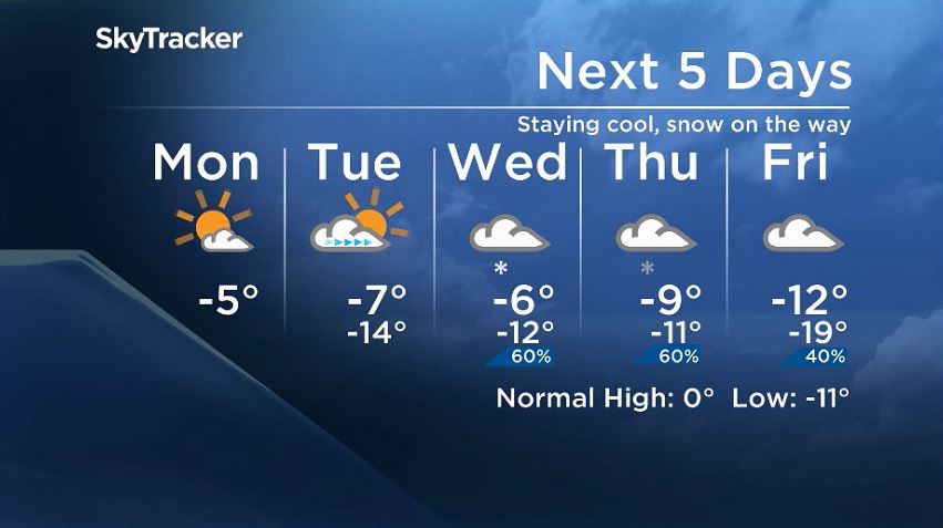
This week temperatures will be staying below the freezing mark and below seasonal. We will also see more snow later this week.

Get breaking National news
Monday and part of Tuesday will stay clearer thanks to high pressure around the western prairies. As it moves away to the southeast, it will give way to a low-pressure system building south of the border that will bring snow to southern Manitoba.


Weather models are in agreement that there will be snow Wednesday and through Wednesday night but the totals vary. Over the span of Wednesday and into Friday, there is potential for five to 10 centimetres of snowfall in Winnipeg. The majority of the snow looks like it would fall later in the day on Wednesday and Wednesday night. Winds don’t look like a significant factor early on but models indicate winds could increase late on Thursday.
As this system clears, temperatures look like they’ll warm up so daytime highs could return to the freezing mark later this weekend.
Comments
Want to discuss? Please read our Commenting Policy first.