

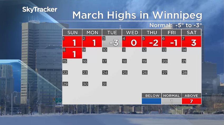
So far this month has heavily favoured the warmer weather to the point that Monday likely feels quite cold and will be a standout so far this month.

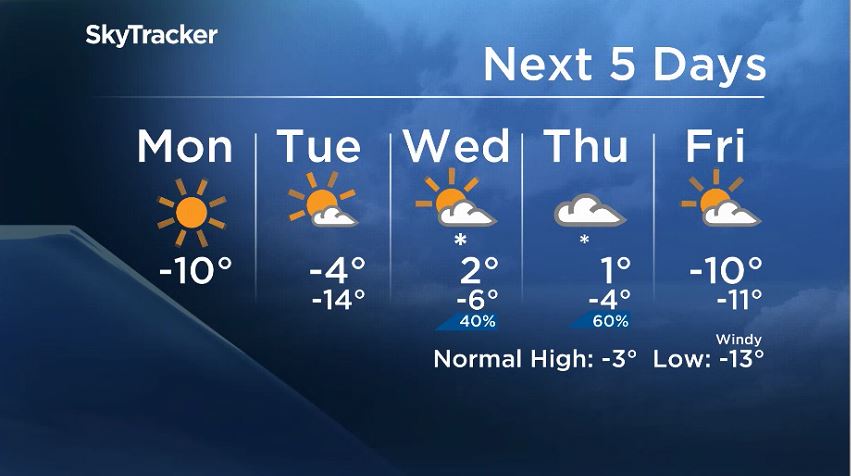
With high pressure moving in after all the snow around central Manitoba this weekend, temperatures dipped into the -20s C Monday morning around most of southern Manitoba. Daytime highs will also stay on the cooler side.
Temperatures are expected to warm up again quickly with more low pressure moving across the prairies. The low will develop over northern B.C. and Alberta and head towards northern Manitoba for Wednesday.

Get daily National news
Snow will move in with this system but not in nearly the same amounts as what fell over the weekend. Snowfall warnings were in place in northern Manitoba, where Environment and Climate Change Canada was reporting snowfall totals in the range of 15-25 centimetres.
According to Environment and Climate Change Canada, as of noon Monday, Flin Flon had received 21 centimetres of snow Sunday into Monday. While there aren’t any official measurements, it is likely Norway House and Island Lake saw similar totals.
- Severe thunderstorms and tornadoes possible across Alberta, in Edmonton region Tuesday
- 2026 is the wettest summer on record in Edmonton — with more storms expected
- France order 4,000 more evacuations as fires ravage southwest Europe
- Monday thunderstorm floods roads, halts traffic and transit across Edmonton


Winnipeg will potentially see some snow with this next system on Wednesday and Thursday and the consensus appears to be just light snow. As of Monday, it looks like two to four centimetres may fall over the two-day period. Snowfall totals around northern Manitoba could still be higher, potentially closer to five to 10 centimetres.
This will coincide with warmer temperatures returning. It looks like both Wednesday and Thursday, temperatures will again be above the freezing mark and back above seasonal values.
Comments
Want to discuss? Please read our Commenting Policy first.