

New photos of Australia from space show the scope and intensity of deadly wildfires raging across much of the country.

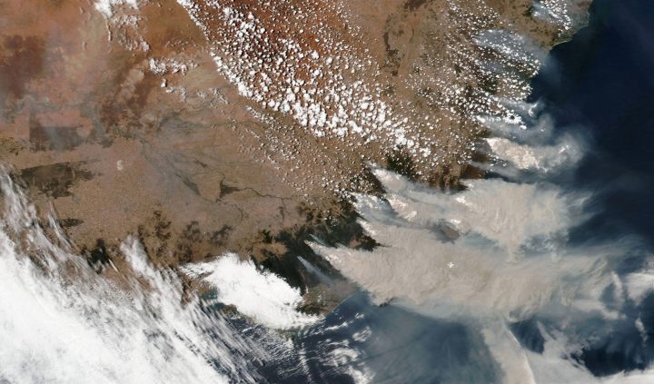
NASA Earth Observatory released two images, taken six months apart, of southeastern Australia, where some of the most severe fires are burning.

The first photo was taken on July 24, 2019 and the second on Jan. 1, 2020.
In the first, the ocean and lush, green land are clearly visible. In the second, a blanket of grey smoke covers the same area entirely.
Images taken on Jan. 3 and 4 from the International Space Station, orbiting 433 kilometres above the Tasman Sea, show wildfires surrounding Sydney, Australia.
While the worst of the fires are concentrated in the south, flames have licked the suburban fringes of Sydney in recent days, bringing fears they will spread further.

The wildfires, which have been raging since September, have so far burned through eight million hectares of land across the country.


New South Wales, Victoria and South Australia have been the hardest hit.

More than 135 fires were burning across New South Wales as of Monday, including nearly 70 that were considered not contained.
- Suspect in fatal Berlin Pride attack killed in confrontation with police
- Israel pitches high-tech trade, safer AI to Canada amid diplomatic tensions
- A person is killed and several are injured at Berlin’s LGBTQ+ march when a car drives into the crowd
- Canadian intern at NATO military HQ arrested in Belgium on spying charge


Twenty-four people and countless animals have died, and nearly 2,000 homes have been destroyed.

Get breaking National news
Images from a Maxar Technologies satellite in orbit show red flames visible from space as wildfires burn in a town east of Victoria called Orbost.


Although bushfires are common in Australia, this season has been dire. Hot, dry weather and prolonged drought have exacerbated fire conditions.
While some rain brought some relief to affected communities Monday, it also created challenges for firefighters trying to execute strategic burns to help bring the fires under control.
Politicians urged citizens to stay vigilant, as the dousing of rain will be far from enough to snuff out the fires.

“We are by no means out of this,” said Victoria state Premier Daniel Andrews. “And the next few days, and indeed the next few months, are going to be challenging.”
— With files from the Associated Press and Reuters
Comments
Want to discuss? Please read our Commenting Policy first.