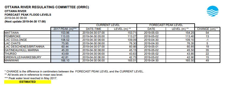
Flood levels in the Britannia area in west Ottawa are expected to increase another 19 centimetres before peaking on Wednesday, according to the Ottawa River Regulation Planning Board’s latest forecast — the same day Ottawa might get hit by snow, ice pellets and rain.

Across the swollen Ottawa River, the water levels near Gatineau/Hull Marina are projected to rise another 35 centimetres before peaking on Thursday, the planning board said in its 9 a.m. forecast on Tuesday, noting that its forecasts are “subject to a high degree of uncertainty.”
Meanwhile, the levels in Lake Coulonge, downstream from Pembroke, reached their peak late on Monday, according to the latest update. Chats Lake is expected to peak on Tuesday.
Due to what the planning board has described as “significant” spring runoff (snow melt), as well as heavy precipitation, the Ottawa River has been spilling into and flooding communities bordering the tributary, from Pembroke to Hawkesbury, over the last two weeks.
In some areas, the water has already reached record-breaking heights and many towns and cities — including Ottawa, Clarence-Rockland and Petawawa — have declared states of emergency over the past week as they wage battle against the rising water levels.
In Pembroke, Coulonge Lake, Chats Lake and Britannia, the river levels have already exceeded their height during the peak of the 2017 floods. The river planning board projects levels at all areas along the river will surpass the 2017 peaks by the end of this week.

Get daily National news
WATCH (Apr. 27, 2019): Boats being used to get around in Gatineau as floodwaters swamp streets

And more precipitation is expected this week.
Environment Canada issued a special weather statement for the Ottawa area on Tuesday morning warning of a “messy mix of snow and ice pellets beginning Wednesday morning,” with two to five centimetres possible.
Freezing rain or approximately 15 to 25 millimetres of rain could follow, the weather agency projected.
Depending on the amount of precipitation that falls along the river in the weeks to come, it’s possible the river’s levels could remain at their peak or dip and then experience a second peak, Pierre Poirier, the City of Ottawa’s manager of security and emergency management, said on Monday afternoon during a flood update at city hall.
WATCH (Apr. 29, 2019): Ottawa riverfront park left almost underwater during flood emergency

Ottawa River levels on Tuesday morning (taken from data published by the Ottawa River Regulation Planning Board):
Pembroke
- Levels measured 113.27 metres above sea level (a five-centimetre decrease overnight)
- River expected to rise another 13 centimetres before peaking at 113.40 metres on Thursday
- 2017 peak: 113.03 metres
Lake Coulonge
- Levels measured 109.09 metres, one centimetre less than the peak on Monday
- 2017 peak: 108.52 metres
Chats Lake (Arnprior area)
- Levels measured 76.30 metres (a five-centimetre increase overnight)
- River expected to rise another 5 centimetres before peaking at 76.35 metres on Tuesday
- 2017 peak: 75.95 metres
Lac Deschenes/Britannia
- Levels measured 60.66 metres (an eight-centimetre increase overnight)
- River expected to rise another 19 centimetres before peaking at 60.85 metres on Wednesday
- 2017 peak: 60.44 metres
Gatineau/Hull Marina
- Levels measured 45.15 metres (a six-centimetre increase overnight)
- River expected to rise another 35 centimetres before peaking at 45.50 metres on Thursday
- 2017 peak: 45.20 metres
Thurso (across the river from Clarence-Rockland)
- Levels measured 43.63 (a one-centimetre increase overnight)
- River expected to rise another 22 centimetres before peaking at 43.85 metres on Thursday
- 2017 peak: 43.69 metres
Grenville/Hawkesbury
- Levels measured 42.75 (a one-centimetre increase overnight)
- River expected to rise another 15 centimetres before peaking at 42.90 metres on Thursday
- 2017 peak: 42.81 metres
The Ottawa River Regulation Planning Board monitors and measures water levels along the river and typically posts new forecasts at 9 a.m. and 5 p.m. every day.


Comments
Want to discuss? Please read our Commenting Policy first.