

Two Colorado lows in one week –it’s a lot of winter at once.

A special weather statement was issued Wednesday morning for a large portion of southeast Manitoba — including Winnipeg — by Environment and Climate Change Canada, as there is the potential to see near 10-20 cm of snow.
This is the second Colorado low that was forecasted starting late last week on Global News.
The potential storm track late last week could have had a much wider impact on southern Manitoba, even reaching southeastern Saskatchewan.
The track of this second storm looks to follow a similar path of the one that passed through on the weekend, but will see snow spread out a bit further north.

The current forecast has Winnipeg near the cusp of the high snowfall amounts with around 2-5 cm likely, however there is the potential for more if the storm moves from its current track.
There are also snowfall warnings in place around southeastern Manitoba, including:

Get daily National news
- Sprague – Northwest Angle Provincial Forest
- Steinbach – St. Adolphe – Emerson – Vita – Richer
- Whiteshell – Lac du Bonnet – Pinawa
With such a large storm, Global News Winnipeg is heading into the thick of it, en route to Fargo, N.D.
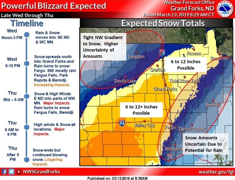


South of the border — around the south east corner of North Dakota — is where the highest snowfall totals will likely hit with 30 plus centimetres possible, along with wind gusts around 80-90 km/h. Blizzard warnings are in place as visibility will be limited.
WATCH: Manitoba CAA shares tips on how to drive if you are caught in whiteout road conditions

Snow will be heaviest Wednesday afternoon and evening with winds staying very strong through Thursday.
You can watch for storm updates on Global News and 6 and 10 as well as Global News Morning. Listen-in on Global News Radio 680 CJOB.
Comments
Want to discuss? Please read our Commenting Policy first.