


It’s shaping up to be one nasty day for weather on Friday.

Environment Canada has issued a wind warning for the eastern parts of Metro Vancouver along with the Fraser Valley, Greater Victoria, Howe Sound and Whistler areas.
That’s on top of light snow that was already in the forecast, though late Thursday Global BC Meteorologist said the likelihood of a serious snow event was declining.
Gordon says snow is expected to begin falling early Friday, meaning commuters should be prepared for the conditions — including having winter tires equipped.
“Our snow event for the Lower Mainland is becoming less likely. It is turning out to be more of a wind event,” said Gordon.
“For the Lower Mainland and Sunshine Coast we could see anywhere from zero to five cenitmetres. That’s not a major snow event. We will see it through the day, on and off, depending on your location.”
The majority of this snow is forecast to fall Friday morning but there is chance of flurries later Friday into Saturday morning.

More serious accumulations are forecast for southern and eastern Vancouver Island.
These areas could see anywhere from five to 15 cm by Saturday morning.
The strong outflow winds will cause “Strait Effect” snow, the South Coast’s version of “lake effect snow.”
This is when strong outflow winds across the Strait of Georgia, pick up moisture and dump snow along eastern and south parts of Vancouver Island.
This region will experience waves of snowfall from Friday morning through Saturday morning.
In the Lower Mainland, TransLink has activated its snow response plan, which includes additional staffing and coordination with local municipalities to ensure priority bus routes are clear.
It is also deploying de-icing trucks and trains to clear SkyTrain rails and trolley wires. If conditions become severe, it says it will rotate out articulated buses and add ‘tire socks’ to buses serving Burnaby Mountain.

Get breaking National news
Nonetheless, commuters are reminded to plan for extra time in their trip, and to watch TransLink’s mobile website for updates.
The City of Vancouver says it’s ready for the snow, and streets operations manager Erin Hoess says extra staff have been shifted.
“We have been treating our priority routes all throughout the last week,” she said.
WATCH: Tire expert explains what makes a tire winter suitable

“Our priority routes are our city’s arterials. That also includes our corner ramps and our bus stops of arterials, our priority hills,” Hoess added. “We have a few priority bike routes identified as well, and of course our emergency routes.”
The city is also reminding people to prepare for the snow in advance and to treat their sidewalks with de-icing material ahead of time.
READ MORE: Surrey Urban Mission hits capacity, seeks donations to help area homeless
Residents of both Surrey and Vancouver are required to clear sidewalks by 10 a.m. the day after a snowfall. People with mobility problems, however, can call 311 in Vancouver to take advantage of the ‘snow angel’ program.
Residents are also encouraged to assist their neighbours if they look like they need help.
Extreme weather shelters have also been activated across the region for the homeless, along with the City of Vancouver’s overnight warming centres.


Windstorm possible
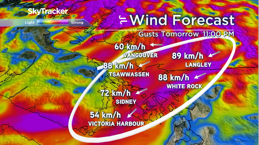
The biggest concern for the Lower Mainland will be strong outflow winds.
These are forecast to develop through the day on Friday but the strongest winds won’t be felt until the evening. Possibly as early as 5:00 p.m. and will continue overnight Friday through Saturday.
These wind gusts could reach 60 to 90 kilometres per hour with the Fraser Valley and south-eastern Metro Vancouver out to Tsawwassen getting hit hardest.
There are also concerns about blowing snow and reduced visibility on the roads and highways, especially out in the Fraser Valley.
Power outages are also very likely, said Gordon.
“Tree branches in this type of cold can be brittle and break easily. These power outages are not expected until we see the strongest winds Friday evening, overnight and Saturday.”
We have good confidence we will see these strong outflow winds from Friday evening through Saturday but there remains uncertainty around how strong exactly.
READ MORE: Possible south coast snow, -40 C temperatures for the interior as arctic blast hits B.C.
The weather is expected to clear Saturday and into Sunday, but that is forecast to bring plunging temperatures with overnight lows hitting -7 C.
- ‘Crippling’: Sechelt could lose 300 temporary foreign workers, mayor says
- Details about the FIFA World Cup Fan Zone in Vancouver released
- ‘No reason to kill our parents’: Closing arguments heard in B.C. double murder trial
- Veteran paramedic testifies he couldn’t tell Myles Gray’s ethnicity due to bruising


Comments
Want to discuss? Please read our Commenting Policy first.