

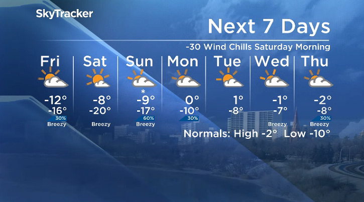
-20 to -30 wind chills return as we take the polar plunge into the weekend.

Saskatoon Forecast
Thursday
After falling back to -7 with wind chills down to -12 overnight, the mercury managed to recover to -2 degrees by daybreak.
Mostly cloudy skies stuck around through the morning with pockets of light snow at times as we warmed up to -1 heading into the noon hour.
Clouds with a chance of snow stick around for the remainder of the day with an afternoon high staying close to the freezing mark.
Thursday Night
The chance of snow increases Thursday evening under mostly cloudy skies as a system passes by south of the city and we cool down into the minus teens overnight.

Get breaking National news
Friday
-22 is what it’ll feel like by Friday with wind chill as you head out the door in the morning under mostly cloudy skies with a slight chance of snow to start the day.
That risk will diminish during the day as skies clear out and late day sunshine rolls in with an arctic high pressure system that’ll keep temperatures in minus double digits and wind chills close to -20 all day.

Weekend
-30 is what it’ll feel like Saturday morning as the mercury plunges back to the -20s to start with mostly sunny skies lasting all day as we warm up toward minus single digits in by afternoon.


The next wave of clouds rolls in on Sunday as a system swings in bringing in a good chance of snow during the afternoon and evening after climbing to a daytime high just into minus single digits.
Work Week Outlook
Mostly to partly cloudy skies return for the third full week of November with afternoon highs flirting with the freezing mark to start the week before cooling back a bit with a chance of flurries later on.
Saskatoon weather outlook is your source for Saskatoon’s most accurate forecast and is your one stop shop for all things weather for central and northern Saskatchewan with comprehensive, in-depth analysis that you can only find here.
For weather on the go download the Global News SkyTracker Weather App for iPhone, iPad or Android.
Comments
Want to discuss? Please read our Commenting Policy first.