
The coldest morning the Central Okanagan has seen in 8 months hit Thursday, as temperatures tumbled to -7 degrees to start the day.

But -11 is what it felt like with the wind chill in the morning, before the mercury finally made it above freezing just before noon under sunny skies.
Blue skies and sunshine continue through Thursday, thanks to an upper ridge helping warm things up to around 5 degrees in the afternoon.
Clear conditions through the evening will knock freezing levels back down to the valley bottom, with little warming expected when clouds roll in overnight.
As a result, when a disturbance rolls through with precipitation, it will both form, remain and fall as snow — not only at higher elevations, but right into the valley bottom.
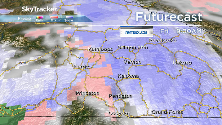
Snow may not start falling until you’ve woken up in the morning, but it is likely to linger into the middle of the day before easing during the afternoon with some late day clearing possible.
This will be the first snowfall of the season in the valley and it will put a damper on daytime heating, with an afternoon high struggling to get up to 3 degrees during the day.
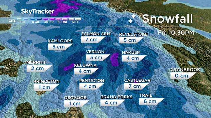
Thanks to the ground being quite warm, despite the fact that 2 to 4 centimetres of snow could fall, most of it will melt on contact with the ground.
Accumulations will be most significant on grassy surfaces, which tend to cool down more quickly than other surfaces.
After Friday’s snow, conditions will cool back down below freezing by a few degrees into Saturday morning.


A mix of sun and cloud will start the day off on Saturday, with a few pockets of mountain snow possible with increasing sunshine during the afternoon and a daytime high back in mid-single digits.

Mostly sunny skies return for Remembrance Day on Sunday, with a chilly start to the day around -4, though the mercury should make it above freezing just in time for outdoor ceremonies around 10 a.m.
Temperatures will climb up to around 6 degrees for an afternoon high before falling back to -4 into Monday morning.
Partly to mostly sunny skies will start off the week on Monday, with clouds rolling in on Tuesday with a chance of showers as daytime highs recover up to the 7 to 8 degree range.

For weather on the go download the Global News SkyTracker Weather App for iPhone, iPad or Android.
- Posters promoting ‘Steal From Loblaws Day’ are circulating. How did we get here?
- Video shows Ontario police sharing Trudeau’s location with protester, investigation launched
- Canadian food banks are on the brink: ‘This is not a sustainable situation’
- Solar eclipse eye damage: More than 160 cases reported in Ontario, Quebec
Comments