

The U.S. is currently bracing for devastating winds and rain as a potentially lethal Hurricane Florence inches closer to the East Coast.

Over a million people have been evacuated as the storm has grown in size even as it was downgraded to a Category 2 hurricane Wednesday night. The massive size of the storm is threatening to damage over 10 million homes.
It’s expected to stall out on the coast over North and South Carolina — much like Hurricane Harvey did in Texas last year — before heading inland and moving north.
“As it moves inland, it’s going to be losing a lot of its energy and strength. So by Sunday morning, it’s expected to be a tropical depression,” said Ian Hubbard, Meteorologist with the Canadian Hurricane Centre.
WATCH: Dramatic images of Hurricane Florence as seen from space

But, as for when and where it will hit Canada, that’s too early to say.
“After that, once we move beyond five days for any kind of system, the range of uncertainty or the possibilities that things change increases an awful lot,” Hubbard said.

Get breaking National news
He says forecasters in Ontario, Quebec and the Maritimes are watching closing to see what impacts in rainfall might have on Canadian regions.
Global News Meteorologist Ross Hull says the earliest Canadians will see any effects is mid-week next week.
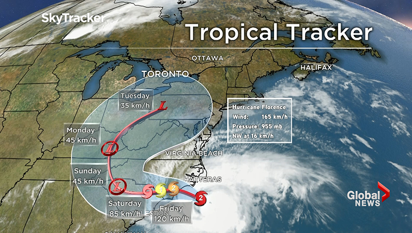
“As to the timing and exact placement of those remnants, there still remains a lot of uncertainty,” he said. “Much of this will depend on the track Florence ends up taking after it moves along the coast.”
While Florence could lose steam by the time it reaches Canada, there’s always a chance of severe weather.
“But there’s always a potential for heavier downpours or significant rainfall amounts in a short time, which can sometimes cause problems. So that’s the kind of thing we’re going to be looking at over the next few days across the country,” Hubbard said.
- N.S. says it’s on schedule to move people with disabilities out of institutions
- Thousands without power in southern Manitoba after storm causes ‘chaos’
- Know the risks, World Cup visitors warned over Canada’s toxic drug supply
- Alberta country music artist Corb Lund expected to hand in anti-coal petition


-
![]() Hurricane Florence weakens to Category 2, storm surge threat remains
Hurricane Florence weakens to Category 2, storm surge threat remains -
![]() Millions brace for Hurricane Florence to make landfall
Millions brace for Hurricane Florence to make landfall -
![]() Hurricane Florence: US military aircraft seen evacuating as storm moves inland
Hurricane Florence: US military aircraft seen evacuating as storm moves inland -
![]() Hurricane Florence: NC governor concerned about what rainfall will mean for river flooding
Hurricane Florence: NC governor concerned about what rainfall will mean for river flooding -
![]() Hurricane Florence: NC governor says ‘millions’ will be without power
Hurricane Florence: NC governor says ‘millions’ will be without power -
![]() Hurricane Florence: NOAA warns of heavy rainfall over multiple days
Hurricane Florence: NOAA warns of heavy rainfall over multiple days -
![]() Hurricane Florence: FEMA says hurricane preparation is ‘a team sport’
Hurricane Florence: FEMA says hurricane preparation is ‘a team sport’


Comparisons to Hurricane Hazel
Earlier this week, Florence was getting compared to Hurricane Hazel — the last Category 4 storm to devastate the Carolinas back in 1954. That storm barreled through the North Carolina killing 19 people and destroying 15,000 homes, the New York Times reports.
It then turned north and headed through the U.S. to Canada — transforming into an extra-tropical Category 1 storm that hit the Toronto area one day later. The Canadian Hurricane Centre said 81 people died from the flooding and rains.
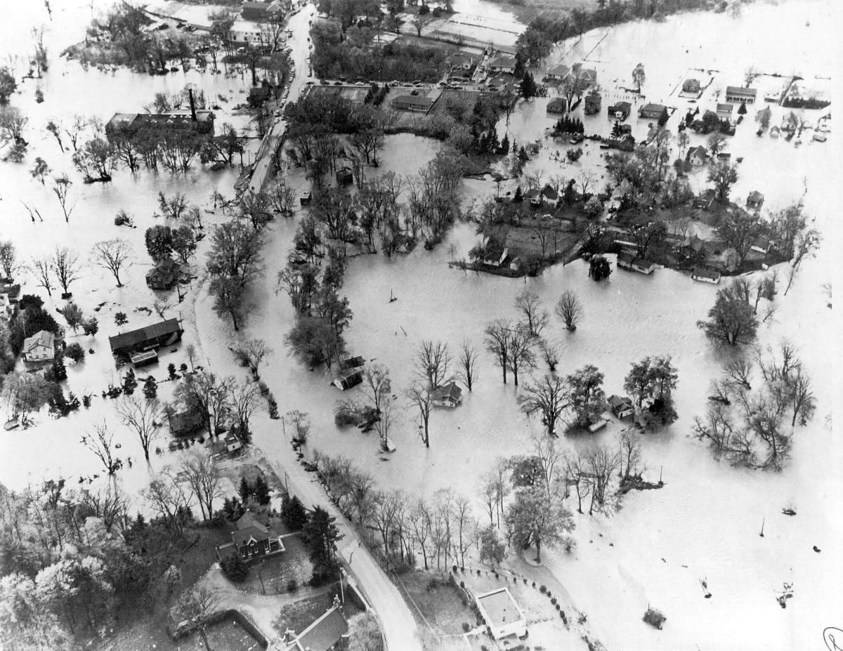
But both Hubbard and Hull said there’s no reason to expect the same from Florence, because there are unique weather patterns for each storm.
“Hazel and Florence are very different storms and have different paths,” Hull said.
“Hurricane Hazel made landfall as a Category 4 hurricane on Oct. 15, continued as a hurricane up to states like Pennsylvania, and just a day later was devastating Toronto,” he explained. “So a very quick moving storm.”
“Florence, over that same time period, will be lingering along the Carolina coasts and weakening as it does so.”
Comments
Want to discuss? Please read our Commenting Policy first.