


People living in various central Alberta regions were battered by high winds, large hail and heavy rain on Friday afternoon and evening, and some areas were also put under a tornado watch.

Environment Canada said the severe thunderstorms generally moved east through central Alberta, between Edmonton and Olds, during the late afternoon and evening hours.
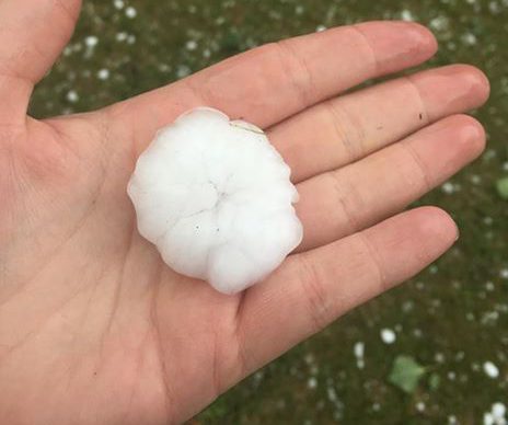
Large hail was the main threat with the storms; there were frequent reports of golf ball sized hail received at the Prairie and Arctic Storm Prediction Centre (PASPC).
Additionally, as the storms moved east, an elongated gust front moved quickly south giving strong wind gusts to many regions in central and southern Alberta through the late evening hours.
The following is a summary of severe weather reports received by Environment Canada as of 9 p.m., including the size of the hail reported:
Hail:
- 5:50 P.M. Crestomere, AB – 27 mm (Loonie)
- 6:00 P.M. Ponoka, AB – 75 to 95 mm (Baseball to Softball)
- 6:50 P.M. Alix, AB – 45 to 64 mm (Golf Ball to Tennis Ball)
- 7:20 P.M. Stettler, AB – 40 mm (Ping Pong Ball)
- 7:15 P.M. Vermillion, AB – 45 mm (Golf Ball)
- 7:50 P.M. Bowden, AB – 45 mm (Golf Ball)
- 7:55 P.M. Trochu, AB – 35 mm (Walnut)
- 8:50 P.M. Olds, AB – 21 mm (Nickel)

Get daily National news
Wind:
- Bellshill, AB – 105 km/h
- Calgary International Airport – 96 km/h
- Crestomere, AB – 91 km/h
- Beiseker, AB – 93 km/h
- Strathmore, AB – 80 km/h
A tornado watch was issued for several regions Friday afternoon, including the Airdrie, Red Deer, Leduc and Drayton Valley areas, as Environment Canada said conditions were favourable for the development of severe thunderstorms that could produce tornadoes.
A severe thunderstorm warning was also issued for areas south of Edmonton later Friday afternoon, as a storm near Bluffton, Alta. was moving east.
Global Edmonton meteorologist Jesse Beyer said severe thunderstorms, including hail and wind gusts of up to 120 km/h were possible for the central Alberta foothills mid- to late-afternoon Friday.
“Many areas in this region will see little action, but for those that do, these storms will be intense,” Beyer said.
Watch below: A number of areas in central Alberta were being warned to brace for severe weather on Friday afternoon. Several people in the Lacombe, Alta. area captured video of hail coming down.


READ MORE: June 2017 storm causes hundreds of thousands of dollars in damage in Red Deer area
Just before noon, Environment Canada issued severe thunderstorm watches for much of central Alberta, spanning an area north of Edmonton south to the Drumheller and Airdrie areas.
The weather agency said condition through central Alberta are most likely to develop strong supercells.
“Some of these supercells may have the potential to become tornadic,” Environment Canada’s weather alert read.
All watches and warnings were lifted later in the evening.
Want your weather on the go? Download the Global News Skytracker weather app for iOS and Android.


Comments
Want to discuss? Please read our Commenting Policy first.