


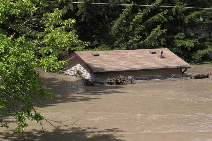
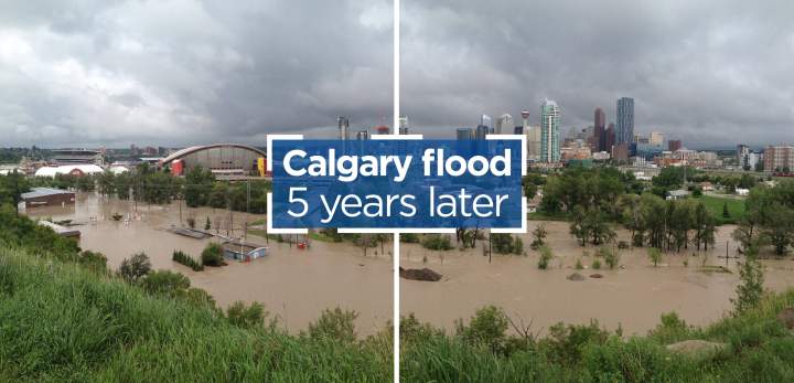
A major flood can change a landscape forever — and that’s just what happened in the Bow and Elbow rivers in 2013 when more water surged through the waterways in a short period of days than had in decades.
The result was what officials called a one-in-100-year flood.
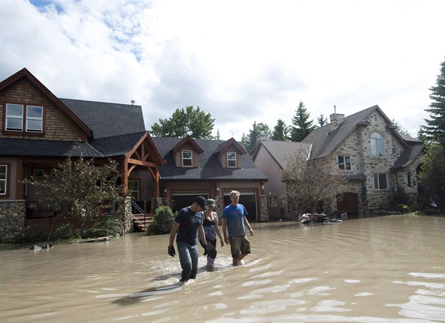
The destruction was widespread, with flooding devastating communities from Banff downstream to Calgary and beyond. Thousands of people were forced to flee, homes were destroyed and the rivers were forever changed.
Infrastructure meant to control the flow of water in the Bow in Calgary, access points for recreational users and the newly finished and highly anticipated Harvie Passage were either severely damaged or eliminated altogether.
When the water settled, there were also major changes to natural areas along the two rivers, namely along the route of the smaller Elbow River.
WATCH: Global Calgary online journalist Heide Pearson joins Global News Morning to talk about a new online series taking a look back at the Calgary flood and what’s changed in the past five years.

So what happens when that much water flows through a river, at that speed and intensity, causing major disruption?
“I think for recreational users, it changed the landscape a lot. That infrastructure has been rebuilt now but it certainly changed access and made things a lot more challenging,” owner of Aquabatics Calgary Simon Coward told Global News.
WATCH: Surging water ripped through the Bow and Elbow rivers in 2013 forever changing the landscape. Here’s Simon Coward with a look at how that historic flood changed the rivers from a user perspective.

A frequent river user, Coward had a front-row seat to the way the rivers changed — some of the areas he would visit with colleagues, friends and students were no longer accessible, which changed the way he conducted his business and leisure activities.
“There were closures of access and egress points, Bowness Park here was closed for at least a year, I believe, while they were restructuring and redoing all of the landscape here to reinforce it in case it happened again,” Coward recalled, while sitting on an eddy in Bowness Park.
“Thousands of people over the summer access the river here, so we had to change access points. Harvie Passage has been closed since.”
Harvie Passage was an elaborate construction around a dangerous weir and had two channels: one for whitewater sporting and one ideal for leisurely river use like the popular activity of floating. It is set to reopen in spring 2019.

Along with that reopening, Coward said the city has done a good job when it comes to bringing the rivers back to their former glory.
“There have been some access issues ongoing. I know the fishing crowd, there’s been some access points taken away from people, especially with bigger boats,” Coward said. “I think it’s largely been resolved… to be honest, once Harvie Passage is open, I think we’re back to ground zero again, we’re back to it being what it was.”
The aftermath of a re-routed river
Both rivers saw significant change to structure and floodplains, according to John Pomeroy, professor of hydrology and Canada research chair of resources and climate change at the University of Saskatchewan.
Although he now lives in Saskatchewan, Pomeroy saw firsthand the destruction of the 2013 flooding, as he lived in Canmore at the time. Being witness to that led him to dive into flood research.
“There was a lot of sediment and debris dumped into these rivers during the flood very, very quickly over a matter of hours.”
“The channels shifted a bit in this case, the deeper parts of the channels moved around. In some of the tributary rivers, particularly the Ghost and Waiparous, there’s widespread devastation in the channels because of the high floodwaters.”
Pomeroy, who also directs several projects at the University of Saskatchewan–including the Global Water Futures program–added many mountain creeks were changed, trees were uprooted and landslides fed more debris into the rivers.
“The Rocky Mountains have rapid rates of erosion and that’s why they’re steep and look very scenic,” he said. “That’s because of being eroded and of course, that happens quickly when there’s lots of energy from melting snow and heavy rainfall that can mobilize the sediment and move it down the mountains.”
Forever changed - Elbow Falls
The power of nature can completely change a landscape and five years after the historic 2013 flooding, Elbow Falls in Bragg Creek is proof of that power.
The Elbow River rose three-and-a-half metres higher than normal and saw flow rates 25 times higher than average in those few days.
The fast-flowing, powerful water overflowed the river’s banks, permanently changing its course by shifting the riverbed further to the south.
Asphalt paths crumbled into the riverbed, trails were covered by mud. The day-use area with picnic tables and benches was totally destroyed.

Most notable is the change to the waterfall: before the flood, fresh glacier water flowed over an almost 15-foot drop.
Now, the riverbed and bowl-shaped cave beneath the falls have been filled in with large boulders and rocks, making it significantly smaller and shorter. Photos also show significantly less water flowing over the falls.
“We have to realize this is what rivers do,” Pomeroy said. “They are trying to expend their energy and they shift their channels and erode and deposit debris as a result of this.”
Pomeroy said the natural ecosystem around Bow Falls has likely rebounded in the past five years and he expects the ecological impacts were minimal.
From a tourist standpoint though, Elbow Falls will never be restored to the attraction that thousands of visitors flocked to each year.
'Very different now from what it was'
It’s also important to recognize the changes the rivers saw as a result of people interacting with the landscape, Pomeroy said, pointing out “the reservoirs now operate differently as a result of the flooding and management decisions made.”
“Some of the settlements have changed in terms of where people live and the dikes and other protections like this have shifted over time, as well,” he said.
“So very much is very different now from what it was five years ago.”
Infrastructure like the Glenmore Dam and man-made Ghost Lake made a significant difference in the way water flowed in the rivers during those peak times.
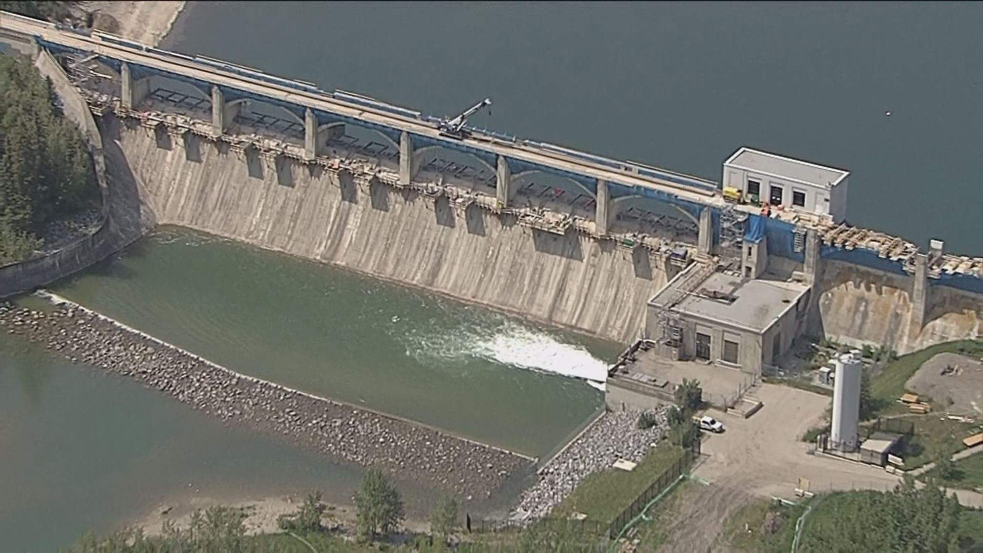
The Ghost Dam, located in the Rocky Mountains near the town of Cochrane and operated by TransAlta, was opened during the 2013 flood, significantly increasing the amount of water flowing downstream. Since then, the province has struck a deal with TransAlta to work together and use the reservoir for flood mitigation.
While Coward said much of the infrastructure is back in place and more river users than ever are taking to the fresh water, some changes from the historic flood have been long-lasting.
“If you took a photo of this right now and compared it to a photo before the floods, it almost looks exactly the same–there’s just some nicer rocks and it’s a bit more reinforced,” he said.
“But what we find now is that we tend to have these high-flow advisories earlier… because they’re releasing from the dams upstream more aggressively until mid-July, they’re just trying to pump as much water out of the dams, so they’ve got as much room to fill them if we have a big rain event again.”
Pomeroy said in the past five years, flood and river-mapping technologies have improved, allowing experts to better predict where the biggest impacts will be for future floods.
“If we had more sophisticated flood forecast models at the time it might have been possible to visualize, in a form like that, how the flood would be playing out,” he said.
“This would have given extra warning and reduced uncertainty of warning to the emergency management agencies, to the municipalities, to the residents of the area.”
BELOW: Interactive map showing flood-affected areas in Calgary and resiliency and mitigation projects
He added that extra preparation could have also reduced the amount of damage communities and ecosystems saw.
Looking to the future, Pomeroy said officials should be ready for more record-breaking environmental events, like what happened in 2013, as climate change increasingly becomes a factor in forecasting.
He pointed to natural disasters like the devastating flooding in the U.S. last year as well as widespread flooding this year in New Brunswick and British Columbia as landmark events to learn from.
“All these things are breaking records, so we should be concerned that future climate change will make flooding worse, including in the rivers that will feed into Calgary,” he said.
“This will help guide the ways of water management. So the reservoir, the height of the dikes that are built and the decisions that are made about whether to keep neighbourhoods going—or abandon them as the town of High River wisely did for one of its neighbourhoods that was simply in an indefensible location.”
Information about the City of Calgary’s flood mitigation and resiliency plans, as well as information tips, useful links and other flood-related content can be found on the city’s website.
With files from Alannah Page


Comments
Want to discuss? Please read our Commenting Policy first.