

Wet and cool start to June after a warm, dry May.

Mild May 2018
Warm air flooded into central Saskatchewan throughout the month of May after three months in a row of way colder than normal temperatures.
The majority of the heat was felt on the daytime high end of the scale with the mercury trending nearly five degrees above average with a total of three days above 30 degrees when normally that only happens 0.63 days in May.
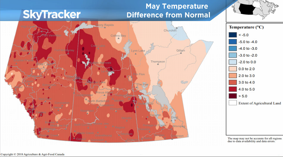
Overnight lows ended up sitting 1.6 degrees higher than seasonal, putting the city a total of 3.2 degrees above average overall.
34.7 millimetres of rain was reported at the airport throughout the month, which is 86 per cent of the city’s normal amount of precipitation of 40.2 millimetres.

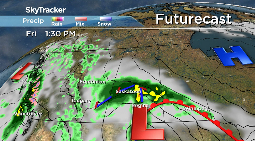
Saskatoon Forecast
Friday
June is normally the wettest month of the year in Saskatoon and it certainly kicked off that way Friday with a low pressure system sliding through Saskatchewan bringing in an organized round of rain.
After a bit of morning mist with a breezy northeasterly winds, the rain kicked in, keeping temperatures in single digits through the morning.
Rain continues into the afternoon with 10 to 20 millimetres expected as we continue to warm up a few degrees into double digits with winds gusting up to 50 km/h.
Friday Night
Winds ease Friday evening as showers taper off overnight and temperatures slide back into mid-single digits.
Saturday
After a slight chance of a few morning showers, clouds will linger for the majority of the day on Saturday with some late day clearing possible before a band of rain with a risk of thunderstorms moves through in the evening.
Cool northwest winds will be a bit breezy during the day as we climb up into the mid-teens for an afternoon high.


Sunday
Sunshine will be back in full swing on Sunday as a short-lived push of high pressure slips through.
Daytime highs will also return to the low 20s with a bit of a breezy wind at times.

Work Week Outlook
The next system slides through Saskatchewan on Monday, bringing with it a good chance of rain and a risk of thunderstorms with an afternoon high in the mid-20s.
Cooler air slides in behind that system, dropping daytime highs to around 20 degrees mid-week with some more sunshine before a gradual warm up back into the mid-20s toward week’s end.

Todd Guggenmos took the June 1 Your Saskatchewan photo in Fort Qu’Appelle:

Saskatoon weather outlook is your source for Saskatoon’s most accurate forecast and is your one stop shop for all things weather for central and northern Saskatchewan with comprehensive, in depth analysis that you can only find here.
Comments