

Risk of snow ahead as the next system gets set to slide through.

Snowfall Warning
Environment Canada has issued a snowfall warning for 10 to 15 centimetres of snow expected in the La Loche, Key Lake and Collins Bay areas.
A low pressure centre developing in southern Alberta will move into Saskatchewan Wednesday bringing an area of heavy snow.
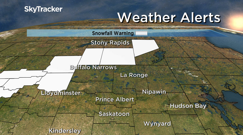
Snow will develop tomorrow morning with amounts of 10 to 15 centimetres forecast before it tapers off Thursday night.
Rapidly accumulating snow could make travel difficult in some locations.
For the latest weather alerts download the Global News Skytracker weather app for iPhone, iPad or Android.
Saskatoon Forecast
Tuesday
Thanksgiving long weekend started and ended in double digits with a cool, single digit day in between.
After wind chill values fell into minus double digits to -12 on Thanksgiving Day, Tuesday morning’s -7 wind chill wasn’t so bad.
Temperatures started the day around -3, but made it up into upper single digits under mostly cloudy skies by noon.
Mostly cloudy skies stuck around for the rest of the day as we climbed up into low double digits for an afternoon high.


Get daily National news
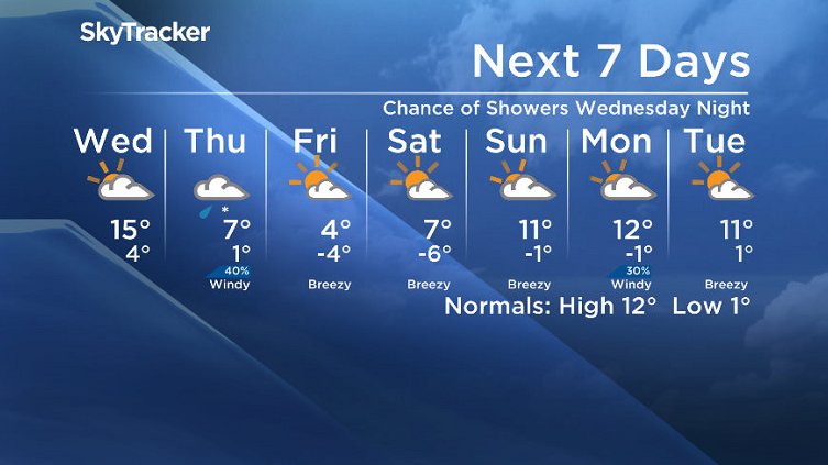
Wednesday
A cloud-packed low pressure system will slide into the area on Wednesday and keep us under mostly cloudy skies all day with a chance of showers into the evening and overnight period.
There will be a kick of heat ahead of this system that will help boost temperatures up into the mid teens in the afternoon.

Thursday-Friday
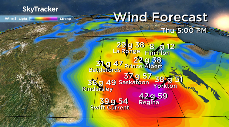
The cold front associated with the system will smash through on Thursday, dropping temperatures from mid-single digits during the day, back toward the freezing mark by evening.
Cool west-northwesterly winds will pick up to 35 km/h with gusts upwards of 50 to 60 km/h under cloudy skies with a chance of rain, snow and a rain-snow mix at times during the day.

The week will end off a bit calmer with a return to some sunshine on Friday as winds start to ease a bit, however it will be much cooler with the mercury struggling to get into mid single digits in the afternoon.
Weekend Outlook
At this point, it looks like Saturday will be the sunnier of the two days with an afternoon high in single digits before more clouds filter in on Sunday with an afternoon high returning to low double digits.
This Your Saskatchewan was snapped by Shanda Bradford near Langham:

Saskatoon weather outlook is your source for Saskatoon’s most accurate forecast and is your one stop shop for all things weather for central and northern Saskatchewan with comprehensive, in depth analysis that you can only find here.
Comments
Want to discuss? Please read our Commenting Policy first.