

UPDATE: All frost advisories mentioned in this story have ended

Summer ends with snow in parts of Saskatchewan!
Frost Advisory
Environment Canada has issued a frost advisory for the Saskatoon, Martensville, Warman, Outlook, Watrous, Kindersley, Rosetown, Biggar, Swift Current, Leader and Shaunavon areas.
The agency says some plants may be damaged or destroyed by frost.
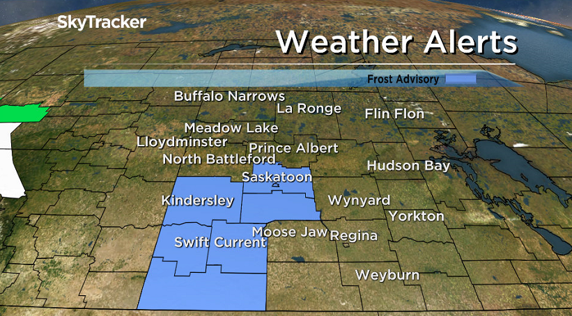
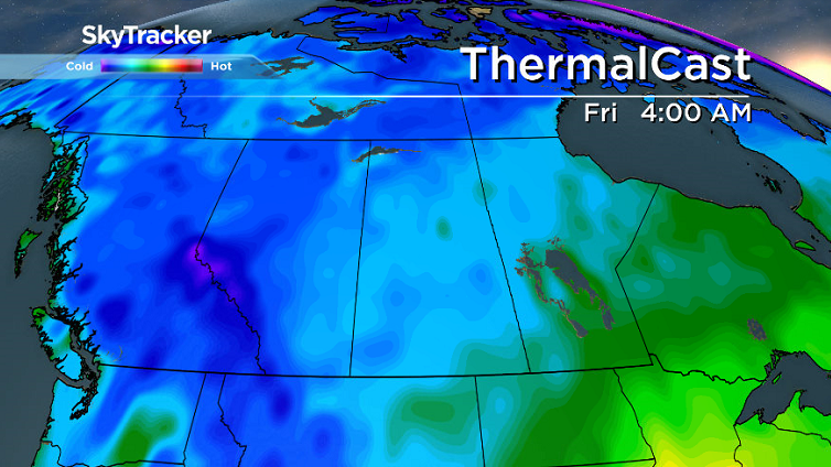
Another cool night lies ahead for western Saskatchewan with temperatures expected to fall into the -1 to -3 degree range overnight.
For the latest weather alerts download the Global News Skytracker weather app for iPhone, iPad or Android.
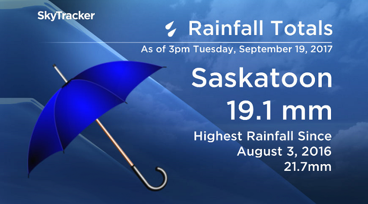
Tuesday’s Heavy Rainfall
More rain fell at the Saskatoon airport on Tuesday than any other day in over a year.
A total of 19.1 millimetres was reported in the city, the highest reported rainfall at the site since August 3, 2016 when 21.7 millimetres fell.
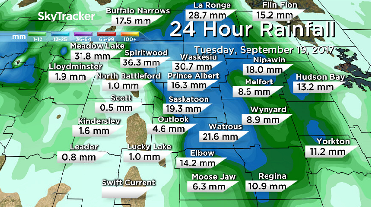
The heaviest precipitation in the province was reported in the Waskesiu and Spiritwood areas, where 30 to 40 millimetres were dumped on the region.
The culprit was a low pressure system swinging through the region that continues to bring more rain to parts of northern Saskatchewan.
The much needed moisture helped so much that it resulted in the provincial fire ban for all of central and northern Saskatchewan Crown land and provincial parks to be lifted, after being out since the end of August.
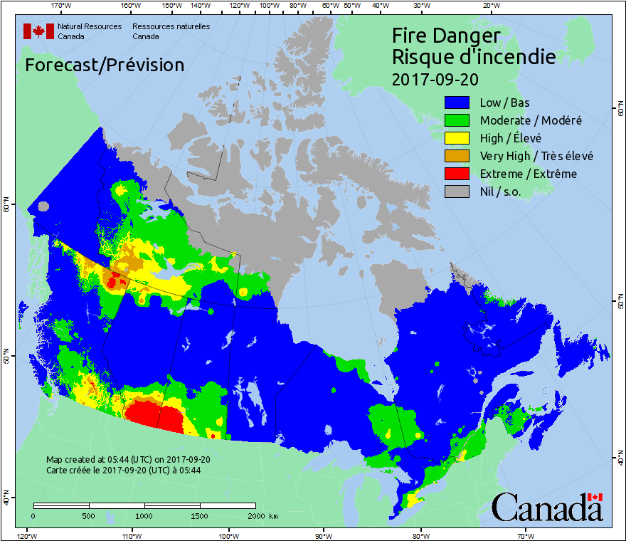
Also, the special air quality statement for smoke in the Pelican Narrows area was also lifted Wednesday morning, after being out for over three-straight weeks.
Saskatoon Forecast

Get daily National news
Wednesday
Saskatoon fell just below freezing mark Wednesday morning with other parts of western Saskatchewan dipping below zero with frost.
We warmed up quickly through the morning through under mostly sunny skies, which helped boost us up into low double digits by midday.
Sunshine stuck around for the afternoon as we continued our climb up into the mid-teens for a daytime high.
Wednesday Night
A front associated with the system that brought the onslaught of rain on Tuesday will swing through northwest Saskatchewan Wednesday night and bring in rain and some wet snow to the region.


Areas like Buffalo Narrows, Stony Rapids and possibly as far south as Meadow Lake and Lloydminster may see some minor accumulations on grassy surfaces overnight.
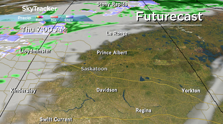
In Saskatoon, just a few clouds are expected to move through as we dip back towards the freezing mark once again with a risk of frost.
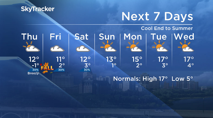
Thursday
As the snow switches back to rain in northwest Saskatchewan on Thursday morning, the Bridge City will see clouds roll back in with a very slight chance of showers after a few sunny breaks possible early in the day.
Temperature-wise, we’ll be rather cool, with the mercury struggling to get up into low double digits for an afternoon high on the final full day of summer.

Friday
Ironically, as fall arrives on Friday at 2:01 p.m. in Saskatchewan, the wintry precipitation will have ended in the province.
Clouds will linger throughout the first day of the new season with a slight chance of showers, particularly later in the day as we rise up to an afternoon high in low double digits at most.
Weekend Outlook
Clouds are expected to linger this weekend with a few sunny breaks possible, particularly on Sunday with daytime highs into low double digits on Saturday before aiming to hit the low teens on Sunday.
This Your Saskatchewan photo was taken in Vanscoy by Margaret Flack:

Saskatoon weather outlook is your source for Saskatoon’s most accurate forecast and is your one stop shop for all things weather for central and northern Saskatchewan with comprehensive, in depth analysis that you can only find here.
Comments
Want to discuss? Please read our Commenting Policy first.