


A winter storm is making its way across B.C.’s South Coast and it’s expected to pack quite a punch.

RCMP detachments across the region are urging drivers to plan ahead and stay off the roads if they don’t have winter tires or don’t have to drive.
Winter storm warnings are in effect for most of the South Coast, incuding:
- East and Inland Vancouver Island
- Greater Victoria
- Elk Valley
- Fraser Valley
- Fraser Canyon
- Howe Sound
- Metro Vancouver
- Southern Gulf Islands
- Sunshine Coast
- Whistler
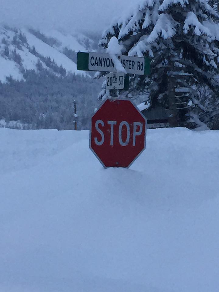
The advisories warn that hazardous conditions were expected as heavy snow falls Wednesday night, possibly followed by freezing rain and heavy downpours as temperatures climb on Thursday
Environment Canada said some areas of the Fraser Canyon and Coquihalla Summit could see 50 centimetres of snow before Thursday, while up to 60 centimetres is forecast to fall on the Sea-to-Sky Highway between Squamish and Whistler.
WATCH: B.C.’s endless winter

-
![]() Global BC viewers celebrate ‘Snow Day’ around the province
Global BC viewers celebrate ‘Snow Day’ around the province -
![]() Students from Surrey to Mission get another ‘snow day’
Students from Surrey to Mission get another ‘snow day’ -
![]() Snow fort in Surrey B.C.
Snow fort in Surrey B.C. -
![]() Chilliwack man’s video show buried cars, snow-clogged streets following blizzard
Chilliwack man’s video show buried cars, snow-clogged streets following blizzard -
![]() Swan dive into the snow
Swan dive into the snow -
![]() Trying their hand at snow kayaking in Chilliwack B.C.
Trying their hand at snow kayaking in Chilliwack B.C. -
![]() Snow kayaking in Chilliwack, B.C.
Snow kayaking in Chilliwack, B.C. -
![]() Snowboarder takes a ride through snowy streets in Chilliwack, B.C.
Snowboarder takes a ride through snowy streets in Chilliwack, B.C.


B.C.’s Emergency Health Services activated their Emergency Operations Centre in advance of the storm.
What to expect
Global BC meteorologist Mark Madryga said the storm came courtesy of a very moist flow of air from the subtropics.
Wednesday morning/afternoon:
Snow will start falling over Vancouver Island this morning, moving across the Strait of Georgia. By early afternoon it is expected to develop over Metro Vancouver and will become heavier later in the afternoon as it moves across the region and the Fraser Valley.
Total snowfall amounts will vary but it is expected between 10 and 20 cm will fall by mid-evening in the Lower Mainland.
In areas such as Howe Sound, as much as 15 cm could fall but between 40 to 60 cm could fall between Squamish and Whistler.
Late afternoon/evening:
Madryga said the heavy snow during the afternoon could make for potentially hazardous driving conditions during the rush hour commute.
Drivers were dealing with blowing snow in some areas while precautions were being taken on the Port Mann Bridge to keep it free of ice and slush.
Traffic appeared lighter than normal in parts of Vancouver as many businesses allowed employees to head home early to avoid the snowfall.
Milder air will begin the transition to rain by later Wednesday evening.
But this will bring freezing rain.
The very mild air will combine with the freezing conditions at ground level and this could make conditions very slippery on the roads and sidewalks.
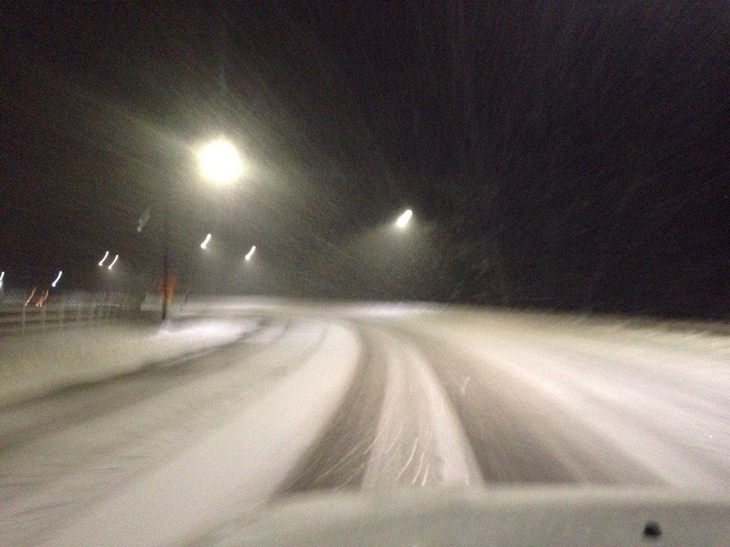
RAW VIDEO: Driving along Highway 7

Evening/overnight
Many parts of Metro Vancouver saw a brief respite from the snow on Wednesday night, but more snowfall and freezing rain is expected.
Many areas were then hit with freezing rain. Drivers on Highway 11 north from Abbotsford to Mission faced a layer of fresh ice on the roadway, making for treacherous conditions.
By Thursday morning, however, temperatures are expected to rise considerably compared to Wednesday with Vancouver expected to reach a high of 8 degrees.


Coquihalla warning
A severe weather warning is in effect for the Coquihalla Highway from Hope to Merritt Wednesday night. Heavy snowfall is expected over the next 24 hours with up to 70 centimetres of snow combined with rain or freezing rain. Drivers are urged to consider alternate travel plans.
School closures
Several schools across Vancouver Island and the Lower Mainland cancelled classes for Wednesday afternoon and evening, including Simon Fraser University, the British Columbia Institute of Technology and the University of Victoria.
Many school districts will wait until early Thursday morning to decide whether classes will be held.
Transit
In anticipation of Wednesday’s winter storm, TransLink prepared for hazardous conditions.
Starting at 2 p.m. Wednesday, they began increasing frequency on SkyTrain Expo and Millennium Lines to accommodate people leaving work early so they are home before the storm hits.
They continued to de-ice rails and SkyTrain attendants were positioned on trains to manually operate them should the snow accumulation on tracks trigger intrusion alarms.
On Canada Line, the exposed guideway was sprayed with anti-icing and de-icing solutions and sand. All trains will be staffed on the exposed guideway, should trains need to be driven manually and additional Canada Line attendants and supervisors will be deployed at stations to assist customers.
To help buses, bus routes were plowed first and push trucks were out to assist vehicles stuck or having difficulty.
Late Wednesday night, TransLink said weather conditions disrupted Canada Line service between Bridgeport and YVR-Airport stations. Buses took passengers from Bridgeport to YVR and all stations in between. Expo and Millennium lines were not impacted.
Vancouver Airport
For those travelling tonight out of Vancouver Airport, check the status of the flight before you leave as there may be some delays.
Travel advisories
An advisory is in effect between Craigalachie to Alberta border. Environment Canada Forecasts are calling for a strong winter storm to cross the area Wednesday evening and into Thursday. Accumulations of up to 30 cm are expected, followed by warming temperatures and rain in some areas, leading to slippery driving conditions. Travellers are advised to drive with caution and allow additional time to reach your destination.
– With files from The Canadian Press
Comments