

UPDATE: All warnings mentioned in this story have ended

Windchill values will be -40 with -30 temperatures in Saskatoon on Saturday before some snow heading into the week before Christmas!
Extreme Cold Warning
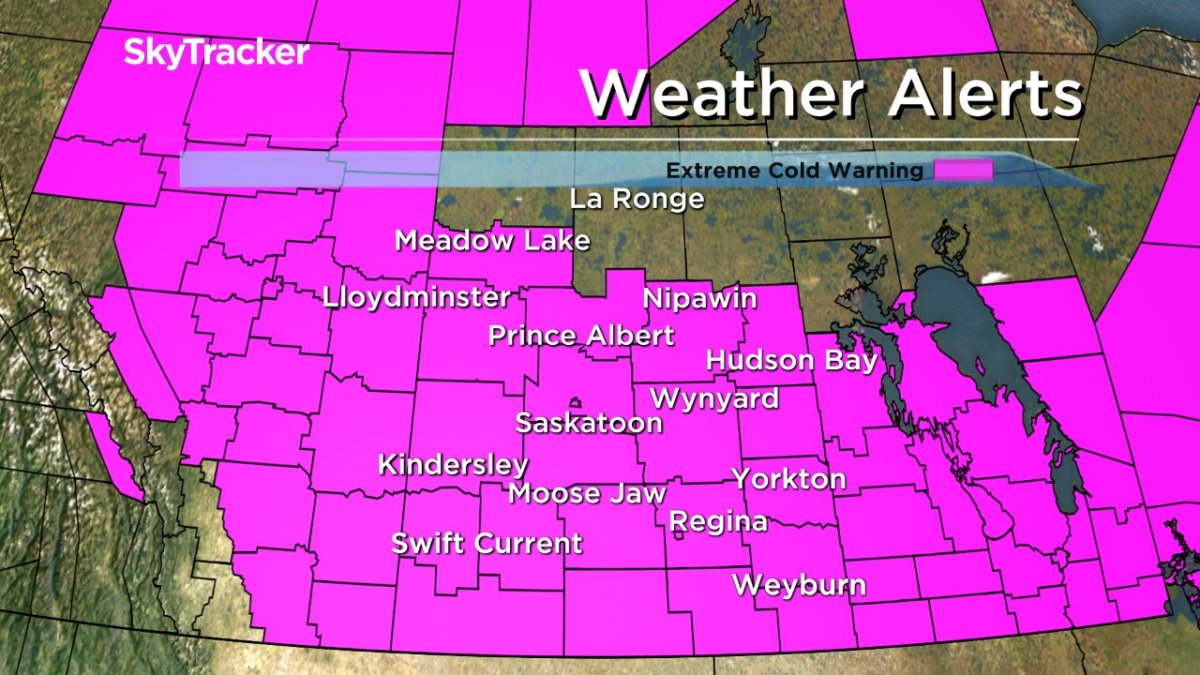
Environment Canada has continued an extreme cold warning for Saskatoon, Regina, and all of central and southern Saskatchewan for a period of extreme cold conditions expected widespread across southern Saskatchewan.
Temperatures of minus 30 to minus 35 combined with light westerly winds of 10 to 15 km/h created extreme windchill values of minus 40 to minus 45 early in the day.
-50 was what it felt like in Val Marie with wind chill Saturday morning, Saskatoon and Regina’s wind chill values fell into the -40s during the overnight period and into the day.
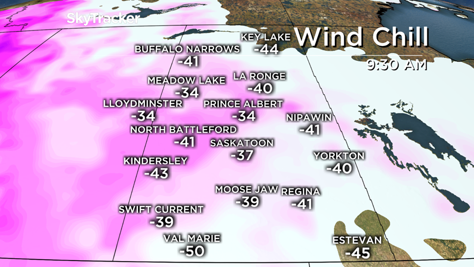
Temperatures could fall this far into the -30s by Saturday morning with -40 wind chills expected.
Temperatures will only climb into the minus 20s on Saturday with windchills moderating into the mid -30s during the afternoon.
Extreme windchill values of minus 40 or lower are possible again Saturday night in many areas before a milder Pacific airmass begins to move in across the province beginning Sunday.
Details on the big warm up on the way can be found below in a full look at the forecast.
Extreme cold warnings are issued when very cold temperatures or wind chill creates an elevated risk to health such as frostbite and hypothermia.
For the latest weather alerts download the Global News Skytracker weather app for iPhone, iPad or Android.
Saskatoon Forecast
Friday
It felt like -38 Friday morning with wind chill as temperatures fell to -27.
The frigid start didn’t improve too much with wind chills staying around -35 with the mercury on climbing into the mid -20s by noon.
Saturday
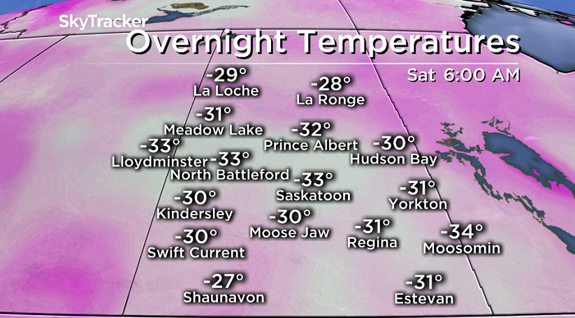
Saturday morning marked the third coldest day of 2016 and the coolest start so far this season with temperatures falling below -30 under mostly clear skies.
Extreme wind chill values around -41 is what it felt like in the morning with temperatures into the -30s before warming up into the low -20s.
Mostly sunny skies through the day will be deceiving as the mercury will only rise into the mid -20s with wind chill values stuck in the -30s all day.


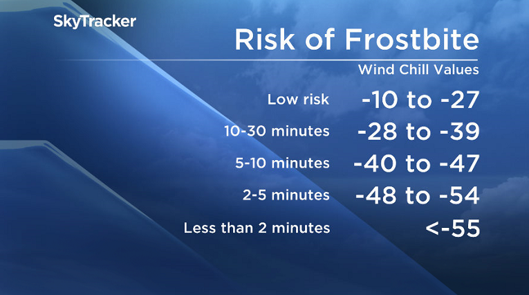
Be sure to bundle up if spending any time outside as in such extreme cold, exposed skin can freeze in a matter of minutes.
The main culprit for the deep freeze is an arctic high pressure system at the surface coupled with a pulse of polar air aloft.
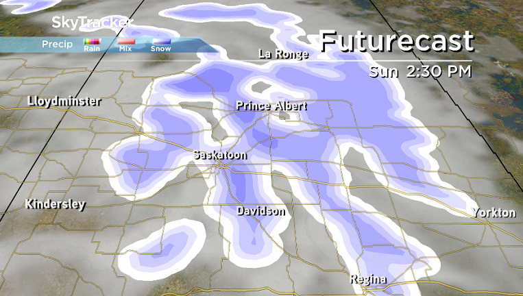
Sunday
We finally start to dig out of the deep freeze on Sunday as a low pressure system swings through.
It’ll bring with it cloudy skies, a good chance of light snow during the day and much more moderate temperatures, helping push the mercury up into the mid-minus teens.
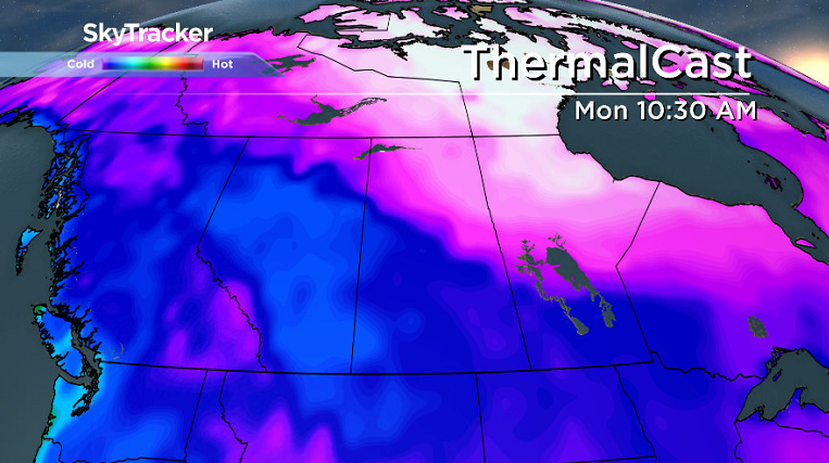
Work Week Outlook
We continue our rebound and recovery into the work week with daytime highs bouncing back into mid-minus single digits!
There is a decent chance of snow Monday into the evening before conditions clear a bit on Tuesday and then a few more clouds into the middle of the week.
The snow is great news for those hoping for at least a bit on the ground heading into the week before Christmas!
Lucas Carrier took this Your Saskatchewan photo in Stony Rapids:

READ MORE: Get a 2017 Your Saskatchewan calendar today
Saskatoon weather outlook is your one stop shop for all things weather for Saskatoon, central and northern Saskatchewan with a comprehensive look at your local forecast that you can only find here.
- Posters promoting ‘Steal From Loblaws Day’ are circulating. How did we get here?
- Video shows Ontario police sharing Trudeau’s location with protester, investigation launched
- Canadian food banks are on the brink: ‘This is not a sustainable situation’
- Solar eclipse eye damage: More than 160 cases reported in Ontario, Quebec
Comments