


WINNIPEG — It was a very wet night in parts southern Manitoba Monday.

Rainfall warnings were issued by Environment Canada Monday night in the southwestern part of the province, and that’s where the numbers were highest.
Here are the totals provided by Environment Canada as of 5 a.m. Tuesday morning:
- Wasagaming: 81.0 mm
- Dauphin: 80.5 mm
- Hamiota: 85.2 mm
- Ste. Rose: 72.1 mm
- McCreary: 70.0 mm
- Virden: 67.7 mm
- Souris: 67.1 mm
- Shoal Lake: 61.3 mm
- Birtle: 53.0 mm
- Melita: 46.1 mm
- Carberry: 48.7 mm
- Boissevain: 43.7 mm
- Brandon: 39.1 mm
- Minnedosa: 38.2 mm

Get daily National news
Get daily Canada news delivered to your inbox so you'll never miss the day's top stories.
By providing your email address, you have read and agree to Global News' Terms and Conditions and Privacy Policy.
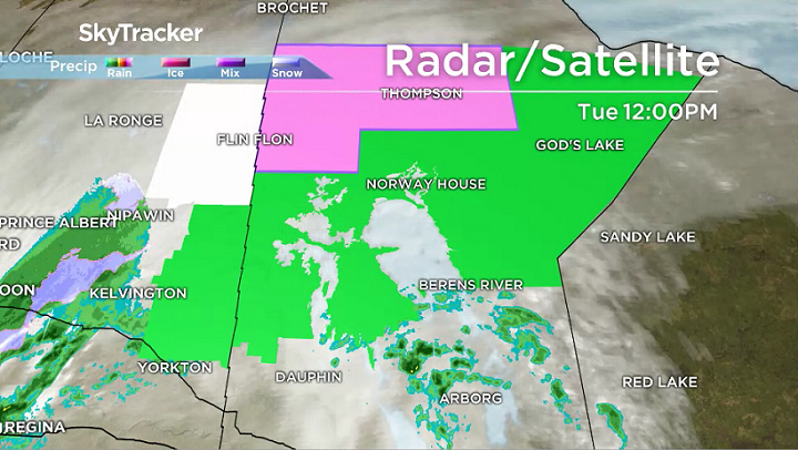
The areas in green depict where rainfall warnings are still in place.
- Storm to bring up to 60 millimetres of rain to parts of Ontario, Quebec
- A ferocious Hurricane Simon nears Mexico with 155 mph winds and flooding fears
- Simon strengthens into a Category 4 hurricane as it approaches Mexico’s coast
- Isaias weakens but flash flooding threat persist as hundred of thousands grapple with power outages


The heaviest rain expected Tuesday into Wednesday will stretch from the Swan River and The Pas areas northeast to Island Lake.
Heavy rain will also move into the Gillam region beginning Tuesday night.
Total rainfall amounts between 50-100 millimetres could fall.


Comments
Want to discuss? Please read our Commenting Policy first.