
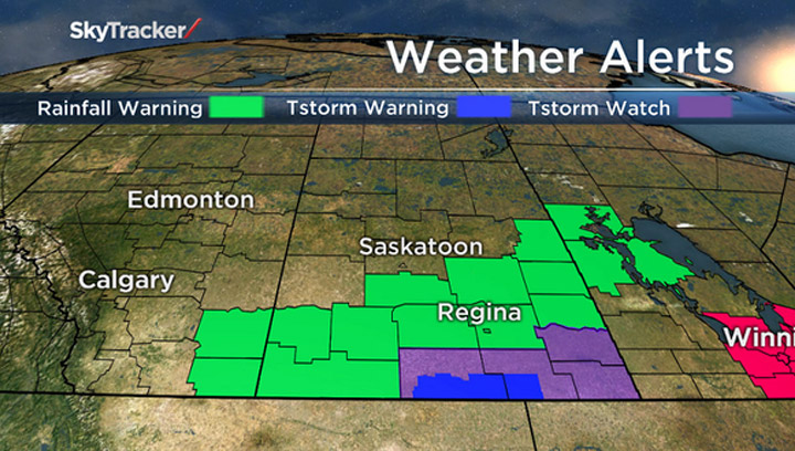
SASKATOON – A rainfall warning has been issued for most of southern Saskatchewan. The warning extends to some central regions of the province.

Environment Canada officials say rain, which at times will be heavy, is expected to drop 50 to 80 mm of rainfall by Tuesday evening. Rainfall warnings are issued when significant rainfall is expected.
The culprit is a low pressure system in eastern Montana that is forecast to deepen and more northward on Monday. As it does, a large area of rain will develop with the system, starting in the southwest corner of the province and spreading eastward throughout the day.
Heavy rain is expected to continue through the night and taper off from west to east during the day on Tuesday.

Get daily National news
Locally higher amounts are possible as some embedded thunderstorms are expected with the system.
READ MORE: Thunderstorms 101: Derechoes, supercells, multi-cells…what it all means
Officials caution that heavy downpours can cause flash floods and water pooling on roads.
For weather on the go download the Global News SkyTracker weather app for iPhone, iPad or Android.
Rainfall warning for:
- Regina
- Leader – Gull Lake
- Swift Current – Herbert – Cabri – Kyle – Lucky Lake
- Shaunavon – Maple Creek – Val Marie – Cypress Hills
- Outlook – Watrous – Hanley – Imperial – Dinsmore
- Moose Jaw – Pense – Central Butte – Craik
- Assiniboia – Gravelbourg – Coronach
- Humboldt – Wynyard – Wadena – Lanigan – Foam Lake
- Fort Qu’Appelle – Indian Head – Lumsden – Pilot Butte
- Hudson Bay – Porcupine Plain
- Kamsack – Canora – Preeceville
- Yorkton – Melville – Esterhazy
Severe thunderstorm watch:
- Assiniboia – Gravelbourg – Coronach
- Estevan – Weyburn – Radville – Milestone
- Moosomin – Grenfell – Kipling – Wawota
- Kamsack – Canora – Preeceville
- Yorkton – Melville – Esterhazy
Tornado watch for:
- Carlyle – Oxbow – Carnduff – Bienfait – Stoughton


Comments
Want to discuss? Please read our Commenting Policy first.