
It’s Groundhog Day! In case you haven’t heard… our Canadian groundhog weather experts came up with a split decision this morning.

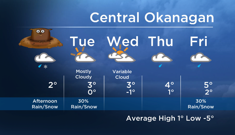
After a snowy Sunday for the north and central regions of our valley and a showery day for the South, another wave of precipitation will move inland by this afternoon. The Columbia and Shuswap are already seeing light spotty precip this morning, but the precip will become more widespread later today.
This push is milder and slightly weaker today, but snow accumulations is expected for the north where it is generally cooler. The central and south will see mixed precipitation and as a result areas by the lake will see minimal accumulation, but higher terrain will see 2-4cm.


A drier trend will be in store as we head into midweek, however, a switch to a southwesterly flow by Wednesday night will feed in more moisture and showers are expected again by Thursday.
Today’s daytime high range: 0 to 4C
~Wesla/Duane
- Posters promoting ‘Steal From Loblaws Day’ are circulating. How did we get here?
- As Canada’s tax deadline nears, what happens if you don’t file your return?
- Video shows Ontario police sharing Trudeau’s location with protester, investigation launched
- Solar eclipse eye damage: More than 160 cases reported in Ontario, Quebec
Comments