
TORONTO – After soaking parts of of the Caribbean this week, Hurricane Cristobal has its sights set on Atlantic Canada.

Cristobal’s path takes the central part of the storm off the eastern coast of Newfoundland. And while the storm won’t make landfall, the island will feel its effects.
READ MORE: Cristobal strengthens into hurricane, heading toward Bermuda
To complicate things, a cold frontal trough is moving southward across Atlantic Canada and is expected to stay in place as Cristobal nears. This will bring heavy rainfall to the region. By Friday morning the two systems will merge into one giant system that will bring high winds and rain.
“The front’s not moving anywhere while that hurricane is present,” said the Canadian Hurricane Centre’s Chris Fogarty. “So you get a stalled front and rainfalls that are occurring over the same spot for hours on end.”
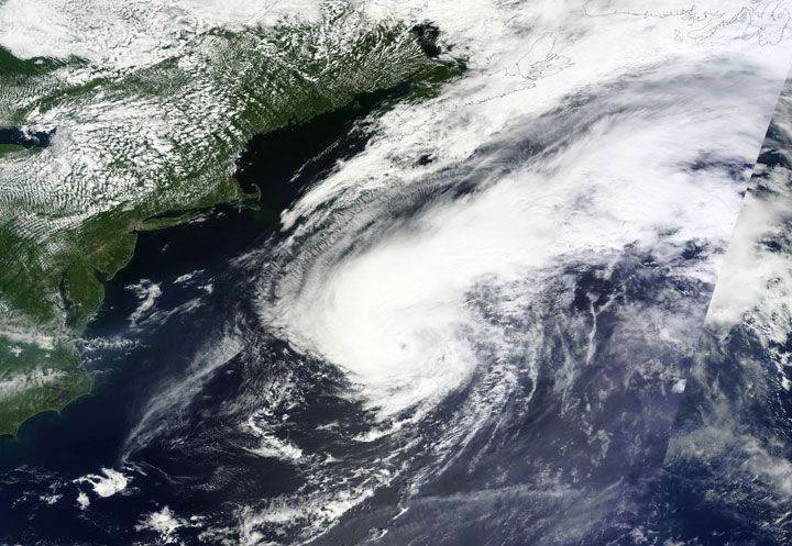
On Thursday, at 1:50 p.m. EDT the Canadian Hurricane Centre said Cristobal was about 700 km south-southeast of Yarmouth, Nova Scotia. The storm’s maximum sustained winds were 130 km/h, making Cristobal a Category 1 hurricane on the Saffir-Simpson scale used to measure the strength of tropical storms.
Wind and rain unrelated to the hurricane are expected to move in overnight into early Friday. The hurricane centre anticipates gusts of 50 to 80 km/h and anywhere between 50 mm and 75 mm of rain.

Get daily National news
There are several rainfall warnings across Newfoundland, including the Avalon Peninsula, Bonavista Peninsula and St. John’s.
High winds and ocean swells of up to three metres are a concern with the incoming Cristobal, so those in the northern Grand Banks should be prepared.
READ MORE: Hurricane season forecasts tied to El Nino
“There’s also a possibility of some rapid false tide-like fluctuations,” Fogarty said. He explained that sometimes, when hurricanes move offshore, they trigger water-level changes several hours after they pass.
“We’ve seen in the past when hurricanes move over the Grand Banks that they can disturb the ocean surface in a way that leads to these very strange, rapid tidal fluctuations in some of the eastern bays of Newfoundland. So you might be looking at the water level and then 15 minutes later it’ll be way down low and then another 15 minutes later, it could come up quite a ways. They’re very hard to predict.
“We just ask people to be on the lookout, because if it comes in high tide, then you can get water topping some of the docks.”
This is the third tropical storm to affect the area this season.
To get real-time weather for your area, download the Global News Skytracker weather app.


Comments
Want to discuss? Please read our Commenting Policy first.